24 Sights in Kenmare Municipal District, Ireland (with Map and Images)
Legend
Welcome to your journey through the most beautiful sights in Kenmare Municipal District, Ireland! Whether you want to discover the city's historical treasures or experience its modern highlights, you'll find everything your heart desires here. Be inspired by our selection and plan your unforgettable adventure in Kenmare Municipal District. Dive into the diversity of this fascinating city and discover everything it has to offer.
1. Carrauntoohil
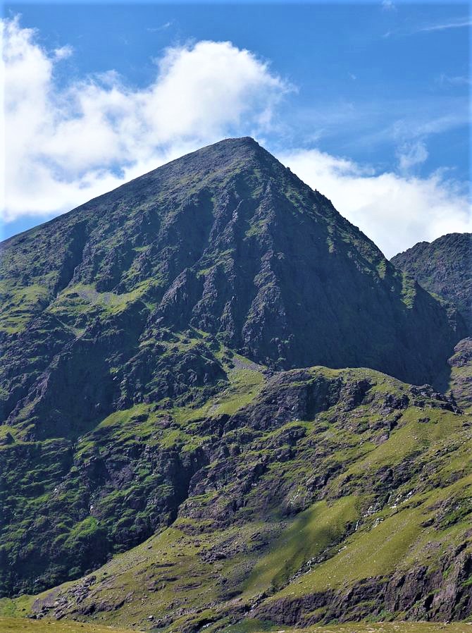
Carrauntoohil, Carrauntoohill or Carrantuohill is the highest mountain in Ireland at 1,038.6 metres. It is on the Iveragh Peninsula in County Kerry, close to the centre of Ireland's highest mountain range, MacGillycuddy's Reeks. Carrauntoohil is composed mainly of sandstone, whose glaciation produced distinctive features on the mountain such as the Eagle's Nest corrie and some deep gullies and sharp arêtes in its east and northeastern faces that are popular with rock and winter climbers.
2. Skellig Monastery

Skellig Michael, also called Great Skellig, is a twin-pinnacled crag 11.6 kilometres (7.2 mi) west of the Iveragh Peninsula in County Kerry, Ireland. The island is named after the archangel Michael, with "Skellig" derived from the Irish language word sceilig, meaning a splinter of stone. Its twin island, Little Skellig, is smaller and inaccessible. The two islands rose c. 374–360 million years ago during a period of mountain formation, along with the MacGillycuddy's Reeks mountain range. Later, they were separated from the mainland by rising water levels.
3. Gallarus Oratory

The Gallarus Oratory is a chapel on the Dingle Peninsula, County Kerry, Ireland. It has been presented variously as an early-Christian stone church by antiquary Charles Smith, in 1756; a 12th-century Romanesque church by archaeologist Peter Harbison in 1970; a shelter for pilgrims by the same in 1994. The local tradition prevalent at the time of Charles Smith attributed it to one Griffith More, being a funerary chapel built by him or his family at their burial place.
4. Knocknapeasta

Cnoc na Péiste, anglicised Knocknapeasta, at 988 metres (3,241 ft), is the fourth-highest peak in Ireland, on the Arderin and Vandeleur-Lynam lists. Cnoc na Péiste is part of the MacGillycuddy's Reeks range in County Kerry. It is one of only two 3,000 ft peaks in the Reeks with a prominence above the Marilyn threshold of 150 metres, and is the highest summit of the Eastern Reeks. In 1943, a USAAF plane crashed into the mountain, killing all five crew, and parts of the wreckage can still be seen in Lough Cummeenapeasta.
5. Beenkeragh

Binn Chaorach is the second-highest peak in Ireland, at 1,008.2 metres (3,308 ft), on both the Arderin and Vandeleur-Lynam lists. It is part of the MacGillycuddy's Reeks range in County Kerry. Beenkeragh also gives its name the infamous Beenkeragh Ridge, the narrow rocky arete between Beenkeragh and Carrauntoohil, Ireland's highest mountain.
6. Derreen Gardens

Derreen Garden lies on a promontory in Kilmakilloge Harbour on the Beara Peninsula, in Tuosist parish, near Kenmare in County Kerry, Republic of Ireland. The 4th Marquess of Lansdowne (1816–1866) initiated the planting of the garden in 1863, but it was his son and heir, The 5th Marquess of Lansdowne (1845–1927), who in his time served as Governor General of Canada, Viceroy of India, and British Secretary of State for Foreign Affairs, who from 1870 onwards gave the garden its present shape. Today it covers more than 60 acres and includes nearly 12 km of paths.
7. Knocknadobar

Knocknadobar at 690 metres (2,260 ft), is the 102nd–highest peak in Ireland on the Arderin scale, and the 123rd–highest peak in Ireland according to the Vandeleur-Lynam scale. Knocknadobar is one of the main mountains of the Iveragh Peninsula in County Kerry, Ireland, and has been one of the most important sites of pilgrimage in Ireland since medieval times.
8. Caher

Caher or Caher East Top at 1,000 metres (3,300 ft), is the third-highest peak in Ireland, on the Irish Arderin and Vandeleur-Lynam classifications. It is part of the MacGillycuddy's Reeks in County Kerry.
9. Caherdaniel Stone Fort
Caherdaniel is a village and townland in County Kerry, Ireland, located on the Iveragh peninsula on the Ring of Kerry. It is on the southwestern side of the peninsula, facing onto Derrynane Bay, at a T-junction on the N70 road.
10. The Bones

The Bones, at 957 metres (3,140 ft) high, is the seventh-highest peak in Ireland on the Arderin list, or the eighth-highest according to the Vandeleur-Lynam list. It is part of the MacGillycuddy's Reeks in County Kerry, and is a small sharp peak on the dramatic Beenkeragh Ridge, and is sometimes mistaken with The Bone, the north-east spur of Maolán Buí, which descends into the Hag's Glen.
11. Cnoc an Chuillinn

Cnoc an Chuillinn, at 958 metres (3,143 ft), is the sixth-highest peak in Ireland on the Arderin list and the seventh-highest peak in Ireland on the Vandeleur-Lynam list. The name is sometimes incorrectly anglicised to Knockacullion, which is a name used for peaks and townlands in other parts of Ireland. Cnoc an Chuillinn is part of the MacGillycuddy's Reeks range in County Kerry.
12. Baurtregaum

Baurtregaum at 851 metres (2,792 ft), is the 13th–highest peak in Ireland on the Arderin scale, and the 18th–highest peak on the Vandeleur-Lynam scale. Baurtregaum is situated at the centre of the massif of the Slieve Mish Mountains on the Dingle Peninsula in County Kerry, Ireland. It is the tallest mountain of the Slieve Mish range, with a number of major subsidiary summits.
13. Derrynane House

Derrynane House was the home of Irish politician and statesman, Daniel O'Connell. It is protected as a national monument and part of a 320-acre (1.3 km2) national historic park. The house is located on the Iveragh peninsula on the Ring of Kerry near the village of Derrynane in County Kerry, Ireland (3.5 km from Caherdaniel.
14. The Big Gun

The Big Gun, at 939 metres (3,081 ft) high, is the ninth-highest peak in Ireland on the Arderin list, or the tenth-highest according to the Vandeleur-Lynam list. It is part of the MacGillycuddy's Reeks in County Kerry, and is also known as Lackagarrin or Foilnabreachaun.
15. Maolán Buí

Maolán Buí, also known by the name Bearna Rua, at 973 metres (3,192 ft) high, is the fifth-highest peak in Ireland on the Arderin list, or the sixth-highest peak in Ireland according to the Vandeleur-Lynam list. Maolán Buí is also known for its narrow north-west spur, called The Bone. It is part of the MacGillycuddy's Reeks in County Kerry.
16. Ballycarbery Castle

Ballycarbery Castle is a castle 3 kilometres (2 mi) from Cahersiveen, County Kerry, Ireland. The castle is high on a grass hill facing the sea and is a short distance from Cahergall Fort and Leacanabuile Fort.
17. Slea Head

Slea Head is a promontory on the westernmost part of the Dingle Peninsula, in southwest County Kerry, Ireland. It can be reached by the R559 road, with the nearest villages being Ballyickeen and Coumeenoole. The headland itself, together with the larger part of Mount Eagle's southern slopes, is formed from steeply dipping beds of the pebbly sandstones and conglomerates of the Slea Head Formation, dating from the Devonian period and traditionally referred to as old red sandstone.
18. Dunkerron Castle
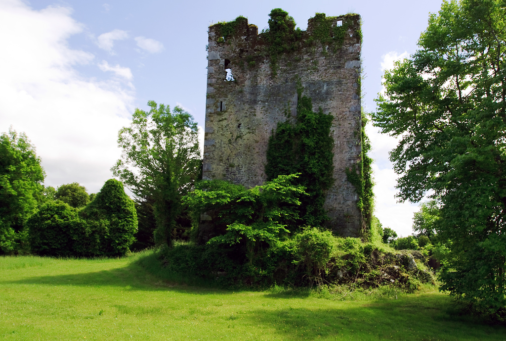
Dunkerron Castle is a ruined four-storey tower house located in Templenoe, near Kenmare, County Kerry, in south-west Ireland. The castle was the family seat of the O'Sullivan Mór family from the late 16th century.
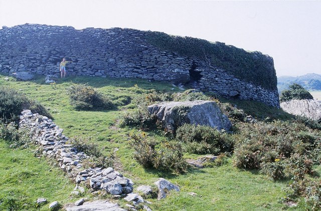
19. Staigue Fort

Staigue or Staig is a ruined stone ringfort eighteen kilometers west of Sneem, on the Iveragh peninsula in County Kerry, Ireland. The fort is thought to have been built during the late Iron Age, probably somewhere between 300 and 400 AD, as a defensive stronghold for a local lord or king.
20. Eightercua

Eightercua Irish: Íoċtar Ċua , meaning ' "the place or holy place or harbor" that is Íoċ or "below" - the word is a specifically geographical term that does not adequately translate into English which does not designate a "place down below" with categorically geographical differentiation') is a four-stone alignment (stone-row) Megalithic tomb, located 1.5 km south-south-east of Waterville, County Kerry, Ireland. The tallest stone reaches 9 feet in height, and the alignment streaches for twenty five feet in an east-west direction. Surrounding artifacts, including remains of a possible tomb and an ancient enclosure, suggest that the site had a ritual purpose at one time. Eightercua is thought to originate from circa. 1700 BC, and by tradition is the burial place of Scéine, wife of the leader of the Milesian invaders, Amergin mac Míled.
21. Brassel Mountain

Brassel Mountain at 575 metres (1,886 ft), is the 261-st highest peak in Ireland, on the Arderin scale. It is part of the MacGillycuddy's Reeks range in County Kerry. Brassel Mountain is the south-east spur of the larger neighbouring peaks, Cnoc an Chuillinn 958 metres (3,143 ft), and Cnoc an Chuillinn East Top 926 metres (3,038 ft). Because of its positioning away from the main ridge of the Reeks, and away from the glens used to access the Reeks, Brassel is less frequently climbed, but can be used as an exit, or entry point to the main ridge.
22. Stumpa Dúloigh

Stumpa Dúloigh also known as Maol, is the highest of the Dunkerron Mountains, part of the Mountains of the Iveragh Peninsula in County Kerry, Ireland. It has a height of 784 metres (2,572 ft) and lies southwest of MacGillycuddy's Reeks.
23. Bray Head Signal Tower

Bray Tower is a signal tower located on Valentia Island in County Kerry, Ireland. The tower was built in 1805 by the British Board of Ordnance during the Napoleonic Wars. It was one of 81 signal towers built between 1804 and 1806 along the Irish coast to communicate naval activity in response to a possible French invasion. The tower was abandoned sometime during the mid-1810s.
24. Ballinskelligs Castle

Ballinskelligs Castle is a castle located near Ballinskelligs on the Iveragh Peninsula in County Kerry, Ireland. The castle is situated on the western shore of Ballinskelligs Bay, on a narrow promontory which is subject to heavy erosion. The castle was constructed by the MacCarthy Mórs in the 16th century to protect the bay from pirates, and possibly in order to charge a tariff on incoming trade vessels.
Share
How likely are you to recommend us?
Disclaimer Please be aware of your surroundings and do not enter private property. We are not liable for any damages that occur during the tours.