100 Sights in San Francisco, United States (with Map and Images)
Legend
Premium Sights
Book tickets, guided tours and activities in San Francisco.
Guided Free Walking Tours
Book free guided walking tours in San Francisco.
Welcome to your journey through the most beautiful sights in San Francisco, United States! Whether you want to discover the city's historical treasures or experience its modern highlights, you'll find everything your heart desires here. Be inspired by our selection and plan your unforgettable adventure in San Francisco. Dive into the diversity of this fascinating city and discover everything it has to offer.
Sightseeing Tours in San FranciscoActivities in San Francisco
Nob Hill is a neighborhood of San Francisco, California, United States that is known for its numerous luxury hotels and historic mansions. Nob Hill has historically served as a center of San Francisco's upper class. Nob Hill is among the highest-income neighborhoods in the United States, as well as one of the most desirable and expensive real estate markets in the country. Prior to Covid-19, it was the most expensive real estate market per metre squared, narrowly beating Monte Carlo, although it has since fallen heavily. It was the only place in the United States so far where market price per square metre exceeded the average yearly salary in the country.

The Exploratorium is a museum of science, technology, and arts in San Francisco, California. Founded by physicist and educator Frank Oppenheimer in 1969, the museum was originally located in the Palace of Fine Arts and was relocated in 2013 to Piers 15 and 17 on San Francisco's waterfront.

The Tin How Temple is the oldest extant Taoist temple in San Francisco's Chinatown, and one of the oldest still-operating Chinese temples in the United States. It is dedicated to the Chinese sea goddess Mazu, who is known as Tin How in Cantonese.

The Palace of Fine Arts is a monumental structure located in the Marina District of San Francisco, California, originally built for the 1915 Panama–Pacific International Exposition to exhibit works of art. It was constructed from concrete and steel, and the building was claimed to be fireproof. According to a metal plate at the rotunda, it was rebuilt under B.F. Modglin, local manager of MacDonald & Kahn, between 1964 and 1967. In the years 1973 and 1974, the columniated pylons were added. It is the only structure from the exposition that survives on site.
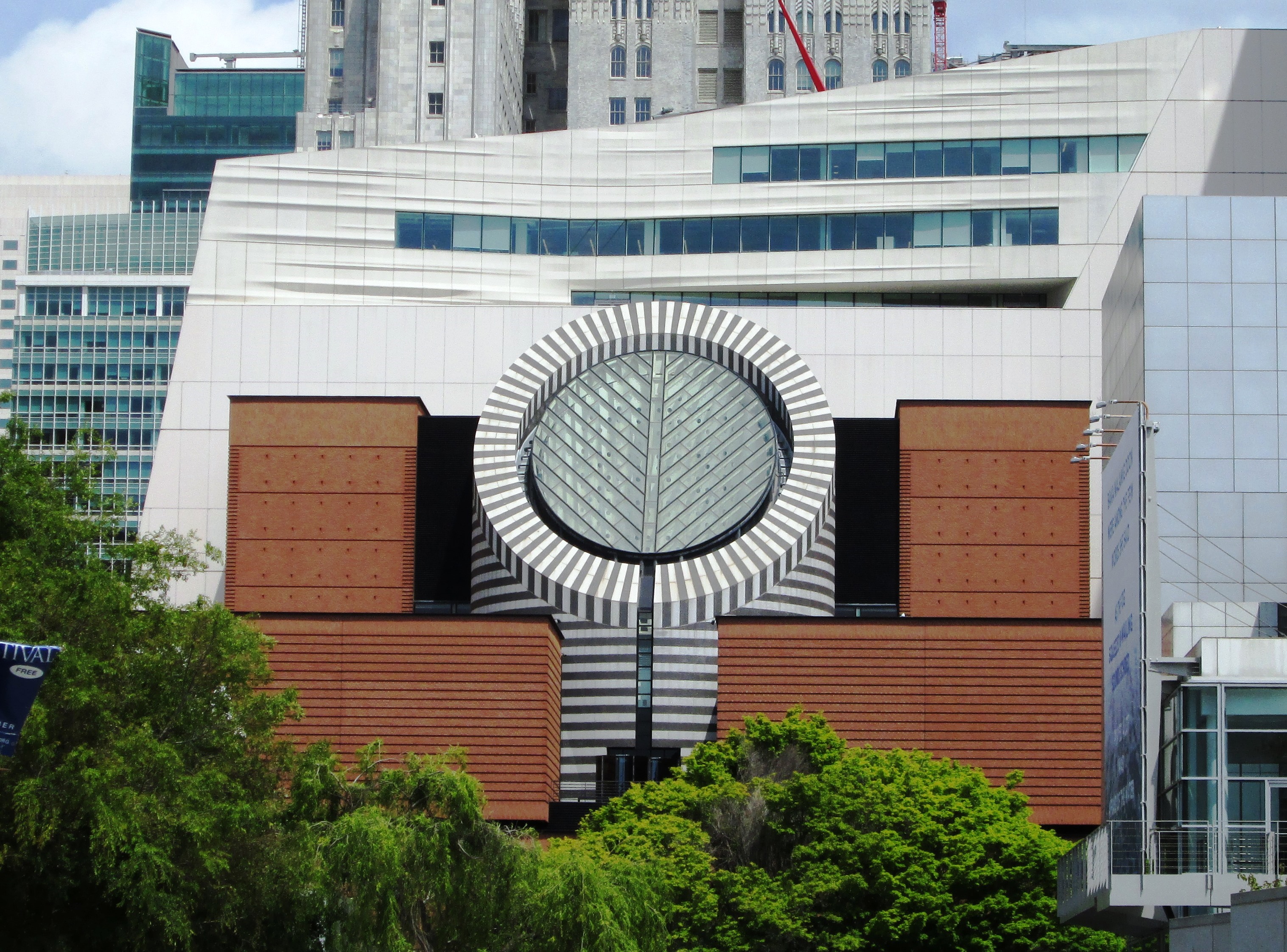
The San Francisco Museum of Modern Art (SFMOMA) is a modern and contemporary art museum and nonprofit organization located in San Francisco, California. SFMOMA was the first museum on the West Coast devoted solely to 20th-century art, and has built an internationally recognized collection with over 33,000 works of painting, sculpture, photography, architecture, design, and media arts. The collection is displayed in 170,000 square feet (16,000 m2) of exhibition space, making the museum one of the largest in the United States overall, and one of the largest in the world for modern and contemporary art.

Grace Cathedral is an American cathedral of the Episcopal Church in San Francisco, California. On top of Nob Hill, Grace is the cathedral church of the Episcopal Diocese of California, led by Bishop Marc Andrus since 2006, while the cathedral's local parish has been led by Dean Malcolm Clemens Young since 2015.

Alamo Square is a residential neighborhood in San Francisco, California with a park of the same name. Located in the Western Addition, its boundaries are Buchanan Street on the east, Turk Street on the north, Baker Street on the west, and Page Street on the south.
Wikipedia: Alamo Square, San Francisco (EN), Operator Website

Coit Tower is a 210-foot (64 m) tower in the Telegraph Hill neighborhood of San Francisco, California, overlooking the city and San Francisco Bay. The tower, in the city's Pioneer Park, was built between 1932 and 1933 using Lillie Hitchcock Coit's bequest to beautify the city of San Francisco. It was added to the National Register of Historic Places on January 29, 2008.

Lombard Street is an east–west street in San Francisco, California, that is famous for a steep, one-block section with eight hairpin turns. The street stretches from The Presidio east to The Embarcadero. Most of Lombard Street's western segment is a major thoroughfare designated as part of U.S. Route 101. The famous one-block section, claimed to be "the crookedest street in the world", is located along the eastern segment in the Russian Hill neighborhood. It is a major tourist attraction, receiving around two million visitors per year and up to 17,000 per day on busy summer weekends, as of 2015.
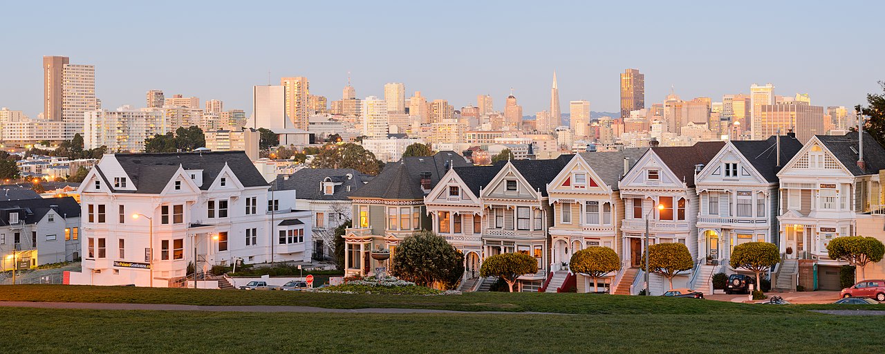
In American architecture, painted ladies are Victorian and Edwardian houses and buildings repainted, starting in the 1960s, in three or more colors that embellish or enhance their architectural details. The term was first used for San Francisco Victorian houses by Elizabeth Pomada and Michael Larsen in their 1978 book Painted Ladies: San Francisco's Resplendent Victorians. Although polychrome decoration was common in the Victorian era, the colors used on these houses are not based on historical precedent.

Fisherman's Wharf is a neighborhood and popular tourist attraction in San Francisco, California, United States. It roughly encompasses the northern waterfront area of San Francisco from Ghirardelli Square or Van Ness Avenue east to Pier 35 or Kearny Street. The F Market streetcar runs through the area, the Powell / Hyde cable car line runs to Aquatic Park, at the edge of Fisherman's Wharf, and the Powell / Mason cable car line runs a few blocks away.

The Legion of Honor, formally known as the California Palace of the Legion of Honor, is an art museum in San Francisco, California. Located in Lincoln Park, the Legion of Honor is a component of the Fine Arts Museums of San Francisco, which also administers the de Young Museum.
Aquarium of the Bay is a public aquarium located at The Embarcadero and Beach Street, at the edge of Pier 39 in San Francisco, California. The aquarium is focused on local aquatic animals from the San Francisco Bay and neighboring rivers and watersheds as far as the Sierra Mountains. Since 2005 the Aquarium has focused its mission on enabling ocean conservation and climate action both locally and globally. It is one of seven institutions under parent company Bay Ecotarium, the largest watershed conservation organization in the Bay Area

Golden Gate Park is an urban park between the Richmond and Sunset districts of San Francisco, California, United States. It is the second-largest park in the city, containing 1,017 acres (412 ha), and the third-most visited urban park in the United States, with an estimated 24 million visitors annually.

The Transamerica Pyramid is a pyramid-shaped 48-story modernist skyscraper in San Francisco, California, United States, and the second tallest building in the San Francisco skyline. Located at 600 Montgomery Street between Clay and Washington Streets in the city's Financial District, it was the tallest building in San Francisco from its completion in 1972 until 2018 when the newly-constructed Salesforce Tower surpassed its height. The building no longer houses the headquarters of the Transamerica Corporation, which moved its U.S. headquarters to Baltimore, Maryland. The building is still associated with the company by being depicted on the company's logo. Designed by architect William Pereira and built by Hathaway Dinwiddie Construction Company, the building stands at 853 feet (260 m). On completion in 1972 it was the eighth-tallest building in the world. It is also a popular tourist site. In 2020, the building was sold to NYC investor Michael Shvo, who in 2022 hired Norman Foster to redesign the interiors and renovate the building.

Union Square is a 2.6-acre (1.1-hectare) public plaza bordered by Geary, Powell, Post, and Stockton Streets in downtown San Francisco, California. "Union Square" also refers to the central shopping, hotel, and theater district surrounding the plaza for several blocks. The area got its name because it was once used for Thomas Starr King rallies and support for the Union Army during the American Civil War, earning its designation as a California Historical Landmark.

Balmy Alley is a one-block-long alley that is home to the most concentrated collection of murals in the city of San Francisco. It is located in the south central portion of the Inner Mission District in Calle 24 between 24th Street and Garfield Square. Since 1973, most buildings on the street have been decorated with a mural.
18. Golden Gate Bridge

The Golden Gate Bridge is a suspension bridge spanning the Golden Gate, the one-mile-wide (1.6 km) strait connecting San Francisco Bay and the Pacific Ocean. The structure links the U.S. city of San Francisco, California—the northern tip of the San Francisco Peninsula—to Marin County, carrying both U.S. Route 101 and California State Route 1 across the strait. It also carries pedestrian and bicycle traffic, and is designated as part of U.S. Bicycle Route 95. Recognized by the American Society of Civil Engineers as one of the Wonders of the Modern World, the bridge is one of the most internationally recognized symbols of San Francisco and California.
19. San Francisco Zoo
The San Francisco Zoo is a 100-acre (40 ha) zoo located in the southwestern corner of San Francisco, California, between Lake Merced and the Pacific Ocean along the Great Highway. In October 2024, A SF city report described the zoo as ‘unsafe for visitors and animals,’ The zoo's main entrance is to the west, on the ocean side. The SF Zoo is owned by the San Francisco Recreation & Parks Department, and managed by the San Francisco Zoological Society, a non-profit 501(c)(3) organization. under a public-private partnership since 1993, receives $4.2 million annually from the city. As of 2016, the zoo housed more than one thousand individual animals, representing more than 250 species. It is noted as the birthplace of Koko the gorilla, and, from 1974 to 2016, the home of Elly, the oldest black rhinoceros in North America.
Wikipedia: San Francisco Zoo (EN), Website, Twitter, Tiktok, Facebook, Instagram, Youtube
20. GLBT History Museum
The GLBT Historical Society maintains an extensive collection of archival materials, artifacts and graphic arts relating to the history of LGBTQ people in the United States, with a focus on the LGBT communities of San Francisco and Northern California.
Wikipedia: GLBT Historical Society (EN), Website, Facebook, Instagram, Youtube
21. Toni Rembe Theater

The American Conservatory Theater (ACT) is a nonprofit theater company in San Francisco, California, United States, that offers both classical and contemporary theater productions. It also has an attached acting school.
22. USS Pampanito

USS Pampanito (SS-383/AGSS-383), a Balao-class submarine, is a United States Navy ship, the third named for the pompano fish. She completed six war patrols from 1944 to 1945 and served as a United States Naval Reserve training ship from 1960 to 1971. She is now a National Historic Landmark, preserved as a memorial and museum ship in the San Francisco Maritime National Park Association located at Fisherman's Wharf in San Francisco, California.
23. South Park

South Park is a small urban park and eponymous neighborhood in the larger South of Market neighborhood of San Francisco, California, consisting of 0.85 acres of public ground. The neighborhood centers on the small, oval-shaped park and South Park Street, which encircles the park. South Park is bounded by Second, Third, Bryant, and Brannan streets.
24. Japanese Tea Garden

The Japanese Tea Garden in San Francisco, California, is a popular feature of Golden Gate Park, originally built as part of a sprawling World's Fair, the California Midwinter International Exposition of 1894. Though many of its attractions are still a part of the garden today, there have been changes throughout the history of the garden that have shaped it into what it is today.
Wikipedia: Japanese Tea Garden (San Francisco) (EN), Operator Website
25. City Lights Booksellers

City Lights is an independent bookstore-publisher combination in San Francisco, California, that specializes in world literature, the arts, and progressive politics. It also houses the nonprofit City Lights Foundation, which publishes selected titles related to San Francisco culture. It was founded in 1953 by poet Lawrence Ferlinghetti and Peter D. Martin. Both the store and the publishers became widely known following the obscenity trial of Ferlinghetti for publishing Allen Ginsberg's influential collection Howl and Other Poems. Nancy Peters started working there in 1971 and retired as executive director in 2007. In 2001, City Lights was made an official historic landmark. City Lights is located at 261 Columbus Avenue. While formally located in Chinatown, it self-identifies as part of immediately adjacent North Beach.
Wikipedia: City Lights Bookstore (EN), Website, Opening Hours, Youtube
26. Pier 39 Sea Lions

Pier 39 is a shopping center and popular tourist attraction built on a pier in San Francisco, California. At Pier 39, there are shops, restaurants, a video arcade, street performances, the Aquarium of the Bay, virtual 3D rides, and views of California sea lions hauled out on docks on Pier 39's marina. A two-story carousel is one of the pier's more dominant features, although it is not directly visible from the street and sits towards the end of the pier. The family-oriented entertainment and presence of marine mammals make this a popular tourist location for families with kids.
27. Conservatory of Flowers

The Conservatory of Flowers is a greenhouse and botanical garden that houses a collection of rare and exotic plants in Golden Gate Park, San Francisco, California. With construction having been completed in 1879, it is the oldest building in the park. It was one of the first municipal conservatories constructed in the United States and is the oldest remaining municipal wooden conservatory in the country. For these distinctions and for its associated historical, architectural, and engineering merits, the Conservatory of Flowers is listed on the National Register of Historic Places and the California Register of Historical Places. It is a California Historical Landmark and a San Francisco Designated Landmark.
28. San Francisco Mint

The San Francisco Mint is a branch of the United States Mint. Opened in 1854 to serve the gold mines of the California Gold Rush, in twenty years its operations exceeded the capacity of the first building. It moved into a new one in 1874, now known as the Old San Francisco Mint. In 1937 Mint operations moved into a third building, the current one, completed that year.
Wikipedia: San Francisco Mint (EN), Website, Heritage Website
29. Balclutha

Balclutha, also known as Star of Alaska, Pacific Queen, or Sailing Ship Balclutha, is a steel-hulled full-rigged ship that was built in 1886. She is representative of several different commercial ventures, including lumber, salmon, and grain. She is a U.S. National Historic Landmark and is currently preserved at the San Francisco Maritime National Historical Park in San Francisco, California. She was added to the National Register of Historic Places on 7 November 1976.
30. Asian Art Museum of San Francisco

The Asian Art Museum of San Francisco – Chong-Moon Lee Center for Asian Art and Culture is a museum in San Francisco, California that specializes in Asian art. It was founded by Olympian Avery Brundage in the 1960s and has more than 18,000 works of art in its permanent collection, some as much as 6,000 years old. Its logo is an upside down letter A, which also looks like a letter V with a line through it.
31. International Art Museum of America
The International Art Museum of America (IAMA), originally the Superb Art Museum of America, is an art museum located at 1023 Market Street between 6th and 7th Streets in the South of Market (SoMa) neighborhood of San Francisco, California. It was founded in 2011 by H. H. Dorje Chang Buddha III, an artist who claims to be a reincarnation of the Buddha Vajradhara, and originally only contained works by him. In an interview with Huffington Post, Dyana Curreri-Ermatinger, the museum's director, denied that the museum was part of a cult, saying that its mission was "to provide a place that is serene and peaceful in the otherwise chaotic environment of Central Market".
Wikipedia: International Art Museum of America (EN), Website
32. Mount Davidson

Mount Davidson is the highest natural point in San Francisco, California, with an elevation of 928 feet (283 m). It is located near the geographical center of the city, south of Twin Peaks and Portola Drive and to the west of Diamond Heights and Glen Park. It dominates the southeastern view from most of Portola Drive. It is one of San Francisco's many hills and one of its original "Seven Hills".
33. Warfield Theatre

The Warfield Theatre, colloquially called The Warfield, is a 2,300-seat music venue located in the Theatre District in downtown San Francisco, California, United States. It was built as a vaudeville theater and opened as the Loews Warfield on May 13, 1922.
34. Saints Peter and Paul Church

Saints Peter and Paul Church is a Catholic church in San Francisco's North Beach neighborhood. Located at 666 Filbert Street, it is directly across from Washington Square and is administered by the Salesians of Don Bosco. It is known as "la cattedrale italiana dell'Ovest", or the Italian Cathedral of the West, and has served as the home church and cultural center for San Francisco's Italian-American community since its consecration. It offers English, Italian, and Cantonese-language services.
35. C. A. Thayer

C.A. Thayer is a schooner built in 1895 near Eureka, California. The schooner has been preserved and open to the public at the San Francisco Maritime National Historical Park since 1963. She is one of the last survivors of the sailing schooners in the West coast lumber trade to San Francisco from Washington, Oregon, and Northern California. She was designated a National Historic Landmark on 13 November 1966.
36. Alcatraz Island Lighthouse

Alcatraz Island Lighthouse is a lighthouse—the first one built on the U.S. West Coast—located on Alcatraz Island in California's San Francisco Bay. It is located at the southern end of the island near the entrance to the prison. The first light house on the island was completed in 1854, and served the bay during its time as a Citadel and military prison. It was replaced by a taller concrete tower built in 1909 to the south of the original one which was demolished after it was damaged due to earthquake in 1906. The automation of the lighthouse with a modern beacon took place in 1963, the year Alcatraz closed as the Alcatraz Federal Penitentiary. It is the oldest light station on the island with a modern beacon and is part of the museum on the island. Although when viewed from afar it easily looks the tallest structure on Alcatraz, it is actually shorter than the Alcatraz Water Tower, but as it lies on higher ground it looks much taller.
37. Eppleton Hall

Eppleton Hall is a paddlewheel tugboat built in England in 1914. The only remaining intact example of a Tyne-built paddle tug, and one of only two surviving British-built paddle tugs, she is preserved at the San Francisco Maritime National Historical Park in San Francisco, California.
38. SS City of Rio de Janeiro

The SS City of Rio de Janeiro was an iron-hulled steam-powered passenger ship, launched in 1878, which sailed between San Francisco and various Asian Pacific ports. On 22 February 1901, the vessel sank after striking a submerged reef at the entry to San Francisco Bay while inward bound from Hong Kong. Of the approximately 220 passengers and crew on board, fewer than 85 people survived the sinking, while 135 others were killed in the catastrophe. The wreck lies in 287 feet (87 m) of water just off the Golden Gate and is listed in the National Register of Historic Places as nationally significant.
39. Curran Theatre

The Curran Theatre, located at 445 Geary Street between Taylor and Mason Streets in the Theatre District of San Francisco, California opened in February 1922, and was named after its first owner, Homer Curran. As of 2014, the theater is owned by Carole Shorenstein Hays.
40. Musée Mécanique
The Musée Mécanique is a for-profit interactive museum of 20th-century penny arcade games and artifacts, located at Fisherman's Wharf in San Francisco, California. With over 300 mechanical machines, it is one of the world's largest privately owned collections.
41. Yerba Buena Gardens

Yerba Buena Gardens is the name for two blocks of public parks located between Third and Fourth, Mission and Folsom Streets in the South of Market (SoMA) neighbourhood of San Francisco, California. The first block bordered by Mission and Howard Streets was opened on October 11, 1993. The second block, between Howard and Folsom Streets, was opened in 1998, with a dedication to Martin Luther King Jr. by Mayor Willie Brown. A pedestrian bridge over Howard Street connects the two blocks, sitting on top of part of the Moscone Center convention center. The Yerba Buena Gardens were planned and built as the final centerpiece of the Yerba Buena Redevelopment Area which includes the Yerba Buena Center for the Arts. Yerba Buena Gardens Conservancy operates the property on behalf of the City and County of San Francisco.
42. Eureka

Eureka is a side-wheel paddle steamboat, built in 1890, which is now preserved at the San Francisco Maritime National Historical Park in San Francisco, California. Originally named Ukiah to commemorate the railway's recent extension into the City of Ukiah, the boat was built by the San Francisco and North Pacific Railroad Company at their Tiburon yard. Eureka has been designated a National Historic Landmark and was listed in the National Register of Historic Places on April 24, 1973.
43. San Francisco Botanical Garden

The San Francisco Botanical Garden at Strybing Arboretum is located in San Francisco's Golden Gate Park. Its 55 acres represents nearly 9,000 different kinds of plants from around the world, with particular focus on Magnolia species, high elevation palms, conifers, and cloud forest species from Central America, South America and Southeast Asia.
44. Temple Sherith Israel

Congregation Sherith Israel is a Reform Jewish congregation and synagogue, located in San Francisco, California, in the United States. Founded in 1851 during California’s Gold Rush period, it is one of the oldest synagogues in the United States. In more modern times, the congregation widely known for its innovative approach to worship and lifecycle celebrations. Listed on the National Register of Historic Places, its historic sanctuary building, completed in 1905, is one of San Francisco's most prominent architectural landmarks.
Wikipedia: Congregation Sherith Israel (San Francisco, California) (EN), Website
45. Sentinel Building

Columbus Tower, also known as the Sentinel Building, is a mixed-use building in San Francisco, California, completed in 1907. The distinctive copper-green Flatiron style structure is bounded by Columbus Avenue, Kearny Street, and Jackson Street; straddling the North Beach, Chinatown, and Financial District neighborhoods of the city. Much of the building is occupied by film studio American Zoetrope, and the ground floor houses a cafe named after the company. The Sentinel Building is listed as San Francisco Designated Landmark No. 33.
46. John McLaren Park

John McLaren Park is a park in southeastern San Francisco. At 312.54 acres (126.48 ha), McLaren Park is the third largest park in San Francisco by area, after Golden Gate Park and the Presidio. The park is surrounded mostly by the Excelsior, Crocker-Amazon, Visitacion Valley, Portola and University Mound neighborhoods.
47. Haas-Lilienthal House

The Haas–Lilienthal House is a historic building located at 2007 Franklin Street in San Francisco, California, United States, within the Pacific Heights neighborhood. Built in 1886 for William and Bertha Haas, it survived the 1906 San Francisco earthquake and subsequent fire. The Victorian era house is a San Francisco Designated Landmark and is listed on the U.S. National Register of Historic Places. It was converted into a museum with period furniture and artifacts, which as of 2016 received over 6,500 visitors annually.
48. Washington Square Park

Washington Square is an American park in the North Beach district of San Francisco. It was established in 1847 and is one of the city's first parks. The park is bordered by sidewalk cafes and restaurants such as Mama's (restaurant) and Park Tavern restaurants and the Liguria Bakery, as well as Sts. Peter and Paul Church.
49. Lotta's Fountain

Lotta's fountain is a fountain at the intersection of Market Street, where Geary and Kearny Streets connect in downtown San Francisco, California. It was commissioned by actress Lotta Crabtree in 1875 as a gift to the city of San Francisco, and would serve as a significant meeting point in the aftermath of the 1906 San Francisco earthquake and fire.
50. Comfort Women Column of Strength

The San Francisco Comfort Women memorial is a monument dedicated to comfort women before and during World War II. It is built in remembrance of the girls and women that were sexually enslaved by the Imperial Japanese Army through deceit, coercion, and brutal force. It is approximated that there were around 400,000 "comfort women" from Korea, Taiwan, China, Indonesia, the Philippines and other Asian countries. The site is located near the Saint Mary's Square, at the crossroads of San Francisco Chinatown and the Financial District. The statue "Comfort Women" Column of Strength, by sculptor Steven Whyte, is one of nine and the first sculpture placed in a major U.S. city to commemorate the comfort women.
51. Vermont Street

Vermont Street is a north–south street in the Potrero Hill district of San Francisco, one of a series of streets in the Potrero Hill district named after American battleships. It begins at Division Street near the South of Market area and runs south, paralleling the U.S. 101 freeway. At 22nd Street Vermont Street jumps to the other side of the freeway via a pedestrian bridge. That piece ends at 25th Street; Vermont resumes at 26th Street back on the east side of the freeway and continues to its south end at Cesar Chavez Street.
52. Warden's House

The Warden's House was the home of the wardens of the federal penitentiary on Alcatraz Island, off San Francisco. It is located at the southeastern end of the Main Cellblock, next to Alcatraz Lighthouse. The 3-floor 15-room mansion was built in 1921 according to the Golden Gate National Recreational Area signpost, although some sources say it was built in 1926 or 1929 and had 17 or 18 rooms.
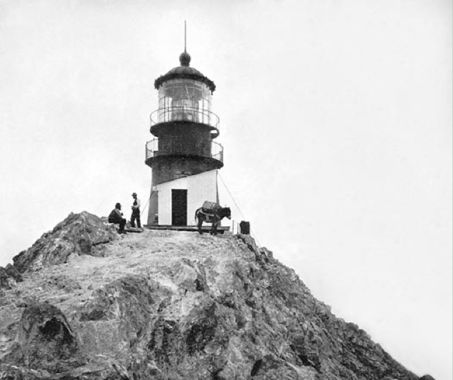
53. Mile Rocks Lighthouse

Mile Rocks Lighthouse is located on a rock about 1 mile (1.6 km) southwest of the Golden Gate Bridge, off of Lands End in San Francisco, California. It was completed in 1906, replacing a nearby bell buoy. In 1966, the light was automated, and the original 85 m (279 ft) tower of the lighthouse was demolished and replaced by a helipad. The lighthouse was at one time painted with alternating red and white rings, but as of 2017, the lighthouse is painted plain white.
54. Top of the Mark

The Top of the Mark is a penthouse level bar located on the nineteenth floor of the Mark Hopkins Hotel on Nob Hill at California and Mason Streets in San Francisco, California. Located at the highest point of downtown San Francisco, on fog-free days the Top of the Mark has views of the financial district, Chinatown, North Beach, The San Francisco Bay, and of Grace Cathedral and Huntington Park.
55. Pink Triangle Memorial

The Pink Triangle Park is a triangle-shaped mini-park located in the Castro District of San Francisco, California. The park is less than 4,000 square feet (370 m2) and faces Market Street with 17th Street to its back. The park sits directly above the Castro Street Station of Muni Metro, across from Harvey Milk Plaza. It is the first permanent, free-standing memorial in America dedicated to the thousands of persecuted homosexuals in Nazi Germany during the Holocaust of World War II.
56. Cable Car Museum
The Cable Car Museum is a free museum in the Nob Hill neighborhood of San Francisco, California. Located at 1201 Mason Street, it contains historical and explanatory exhibits on the San Francisco cable car system, which can itself be regarded as a working museum.
Wikipedia: San Francisco Cable Car Museum (EN), Website, Opening Hours
57. Octagon House

The McElroy Octagon House, also known as the Colonial Dames Octagon House, is a historic octagonal house now located at 2645 Gough Street at Union Street in the Cow Hollow neighborhood of San Francisco, California, United States.
58. Dragon's Gate

The Dragon Gate is a south-facing gate at the intersection of Bush Street and Grant Avenue, marking a southern entrance to San Francisco's Chinatown, in the U.S. state of California. Built in 1969 as a gift from the Republic of China (Taiwan) in the style of a traditional Chinese pailou, it became one of the most photographed locations in Chinatown, along with the older Sing Fat and Sing Chong buildings.
59. Benjamin Franklin

Benjamin Franklin – also known as the Benjamin Franklin Memorial, Benjamin Franklin Statue and Cogswell Historical Monument – is an outdoor sculpture in Washington Square, San Francisco, California.
60. Holocaust Memorial

The Holocaust Memorial at California Palace of the Legion of Honor is a Holocaust memorial in San Francisco, California, in Lincoln Park, overlooking the Golden Gate. It was created by artist George Segal out of white painted bronze. In 1981, the city invited Segal to submit a design for its competition; his plaster maquette is held by the Jewish Museum in New York. The bronze cast was installed in 1984.
Wikipedia: Holocaust Memorial at California Palace of the Legion of Honor (EN)
61. Bernal Hill

Bernal Heights Summit or Bernal Heights Hill is a hill in the San Francisco, California neighborhood of Bernal Heights. Upper elevations are part of Bernal Heights Park, which the San Francisco Recreation & Parks Department manages. At its highest elevation (466 ft.) is a privately owned equipment building and 50-foot tall telecommunications tower. The tower does not have an official name, but some residents call it "Sutrito", as it resembles a shorter version of Sutro Tower. The park and summit are largely surrounded by Bernal Heights Boulevard.
62. Southern Exposure

Southern Exposure (SoEx) is a not-for-profit arts organization and alternative art space founded in 1974 in the Mission District of San Francisco, California. It was originally founded as a grassroots, cooperative art gallery in conjunction with Project Artaud which was a live/work artist community. By the 1980s, they converted the gallery to a community space for supporting emerging artists.
63. Corona Heights Park

Corona Heights Park is a park in the Castro and Corona Heights neighborhoods of San Francisco, California, United States. It is situated immediately to the south of Buena Vista Park. Corona Heights is bounded in part by Flint Street on the east, Roosevelt Way to the north, and 16th Street to the south. The base of the hill is at approximately 300 feet (91 m), while the peak extends to 520 feet (160 m) above sea level.
64. Farallon Island
Farallon Island Light is a lighthouse on Southeast Farallon Island, California. One of the highest lights in California, it was constructed in 1855 to warn ships approaching San Francisco from the west away from the rocky islands. In later years it was shorn of its lantern, but it remains in use.
65. Alta Plaza Park

Alta Plaza Park is a public park in San Francisco, California and caps the top of the western edge of Pacific Heights. It falls under the jurisdiction of the city's Supervisorial District 2. The park is served by several San Francisco Municipal Railway bus lines. It gets its name from the eponymous spring.
66. Notre Dame Des Victoires Church

Église Notre Dame Des Victoires is a Catholic church in San Francisco, California. The church was founded in 1856 to serve the French Catholic immigrants during the Gold Rush. The architectural model for the church is the Basilique Notre-Dame de Fourvière in Lyon, France. In 1887, Pope Leo XIII signed the decree placing Eglise Notre Dame des Victoires under the charge of the Marists and giving it the designation of being a French National Church.
Wikipedia: Notre-Dame-des-Victoires, San Francisco (EN), Website
67. Swedenborgian Church of San Francisco

The Swedenborgian Church is a historic church complex at 2107 Lyon Street in the Pacific Heights neighborhood of San Francisco, California. Built in 1895 for a Swedenborgian congregation, it is considered one of California's earliest pure Arts and Crafts buildings, with design contributions by A. C. Schweinfurth, A. Page Brown, Bernard Maybeck, William Keith, and Bruce Porter. It was designated a National Historic Landmark in 2004.
Wikipedia: Swedenborgian Church (San Francisco, California) (EN)
68. Lime Point

Lime Point Lighthouse is a lighthouse in California, on the northern side of the narrowest part of Golden Gate strait. The lighthouse sits at the base of a steep cliff, very near the North anchorage of the Golden Gate Bridge. It is built on a 100-foot (30 m) long rock spur named Lime Point.
69. Duboce Park

Duboce Park is a small urban park located between the Duboce Triangle and Lower Haight neighborhoods of San Francisco, California. The park is less than one block wide from north to south and two blocks wide from west to east. Its western boundary is Scott Street, and its eastern boundary is Steiner Street. The park is part of the Duboce Park Landmark District.
70. Mohandas K. Gandhi

Mohandas K. Gandhi is a 1988 bronze sculpture of Mahatma Gandhi sculpted by Zlatko Paunov and Steven Lowe. It is located in the plaza to the southeast of the San Francisco Ferry Building along the Embarcadero in San Francisco, California, United States. The 8-foot (2.4 m) tall sculpture is mounted on a block which bears a plaque, raised on two steps. It was a gift from the Gandhi Memorial International Foundation.
71. Water Tower

Alcatraz water tower is on Alcatraz Island in the San Francisco Bay, off the coast of San Francisco, California. It is located on the northwestern side of the island, near Tower No. 3, beyond the Morgue and Recreation Yard. The water tank is situated on six cross-braced steel legs submerged in concrete foundations.
72. The Masonic

The SF Masonic Auditorium is a building and auditorium located atop Nob Hill in San Francisco, California. The building was designed by Bay Area architect Albert Roller (1891-1981), and opened in 1958. It serves as the meeting venue for the Masons of California during their Annual Communication, as well as being used as a concert venue the rest of the year. The administrative offices of the Grand Lodge of California are contained in the upper floors, and the Henry Wilson Coil Library and Museum of Freemasonry is located on the mezzanine. The basement contains a five-level public parking garage.
73. Strawberry Hill

Strawberry Hill is a hill in San Francisco, California, near the center of Golden Gate Park. The hill occupies an entire island in the park's man-made Blue Heron Lake, and is connected by two bridges to the mainland of the park.
74. Ashbury tank

The Auxiliary Water Supply System is a high pressure water supply network built for the city of San Francisco in response to the failure of the existing emergency water system during the 1906 earthquake. The majority of damages to the city from the earthquake were caused not by the seismic event itself, but from the fires that ensued, resulting in the destruction of 80% of the city's property value at the time. The improved water system was originally proposed by San Francisco Fire Department chief engineer Dennis T. Sullivan in 1903, with construction beginning in 1909 and finishing in 1913. The system is made up of a collection of water reservoirs, pump stations, cisterns, suction connections and fireboats. While the system can use both fresh or salt water, it is preferential to not use salt water, as it commonly causes galvanic corrosion in fire equipment.
Wikipedia: San Francisco Fire Department Auxiliary Water Supply System (EN)
75. Alcazar Theatre

The Alcazar Theatre is a 511-seat theatre located at 650 Geary Street, San Francisco, California. The venue is host to many touring productions of Broadway and Off Broadway plays, as well as variety, cabaret, comedians, and other theatrical events.
76. Japan Center

The Japan Center is a shopping center in the Japantown neighborhood of San Francisco, California. It opened in March 1968 and was originally called the Japanese Cultural and Trade Center. It is bounded by Geary, Post, Fillmore, and Laguna. The mall itself is composed of three mall buildings; from west to east, they are the Kinokuniya Mall, Kintetsu Mall, and Miyako Mall. Anchor tenants include Books Kinokuniya and Sundance Kabuki Cinema.
77. Saint Dominics Roman Catholic Church

St. Dominic's Catholic Church is a historic parish in the Lower Pacific Heights neighborhood of San Francisco, California, located at the corner of Bush and Steiner Streets. The parish was established by the Dominican Order in 1873, and the current church, built in the Gothic style, was finished in 1928.
Wikipedia: St. Dominic's Catholic Church (San Francisco) (EN)
78. Pioneer Park
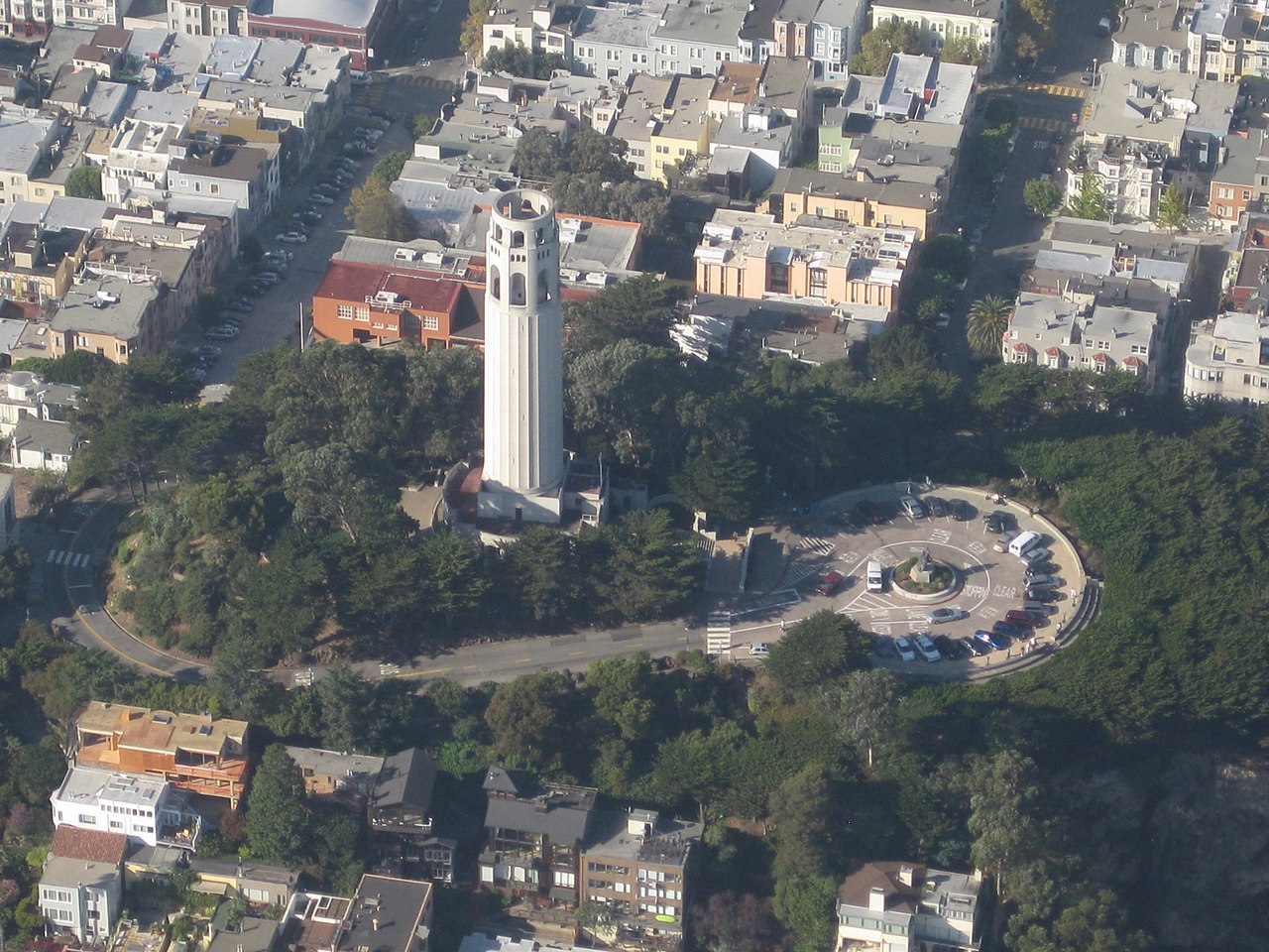
Pioneer Park is a 4.89-acre (19,800 m2) park crowning the top of Telegraph Hill in San Francisco. It was established in 1876 in celebration of the United States Centennial. Prior to establishment of the park, it was the site of the Marine Telegraph Station. The main feature of the park, Coit Tower, was completed in 1933 using a $118,000 bequest left to the city by Lillie Hitchcock Coit in 1929. A bronze statue of Christopher Columbus was placed in the park in 1957, and removed in June, 2020.
79. Saint Anne of the Sunset Catholic Church

St. Anne of the Sunset Catholic Church in San Francisco is a parish of the Archdiocese of San Francisco in San Francisco, California. St. Anne is one of four Sunset District Catholic churches and mainly caters to the Inner Sunset area near Golden Gate Park and the University of California, San Francisco hospital campus.
Wikipedia: St. Anne of the Sunset Church in San Francisco (EN), Website, Twitter, Facebook, Youtube
80. Santa Rosa

Santa Rosa was a Steel Electric-class ferry built in Alameda, California, for Northwestern Pacific Railroad. She started out serving Southern Pacific Railways on their Golden Gate Ferries line on San Francisco Bay.
81. Sun Yat-sen's statue

Sun Yat-sen is an outdoor sculpture depicting the Chinese physician, writer, and philosopher of the same name by Beniamino Bufano, installed in San Francisco's Saint Mary's Square, in 1937, in the U.S. state of California.
82. World War II Memorial

The West Coast Memorial to the Missing of World War II is a monument dedicated to missing soldiers, sailors, marines, coast guardsmen, and airmen of World War II. It is a curved wall of California granite set in a grove of Monterey pine and cypress and overlooking the Pacific Ocean. It bears the name, rank, organization and State of each of the 413 members of the Armed Forces who lost their lives or were buried at sea in the Pacific coastal waters.
Wikipedia: West Coast Memorial to the Missing of World War II (EN)
83. Lafayette Park

Lafayette Park is an 11.49 acres (4.65 ha) park in San Francisco, California, United States. Originally created in 1936, it is located in the neighborhood of Pacific Heights between the streets of Washington, Sacramento, Gough, and Laguna. Located on a hill, the park offers views of many areas, including the city's Marina district, Alcatraz Island and the San Francisco Bay, Buena Vista Park, and Twin Peaks. In addition to both open and treed green spaces, the park includes two tennis courts, a children's playground, an off-leash dog area, restroom facilities, and a picnic area.
84. Macondray Lane

Macondray Lane is a small pedestrian lane on the southeastern side of Russian Hill in San Francisco, California. It forms a wooded enclave that was added to the National Register of Historic Places in 1988 as the Russian Hill–Macondray Lane District.
85. Goddess of Democracy

Goddess of Democracy is a replica of the original Goddess of Democracy statue created during the Tiananmen Square protests of 1989, installed in San Francisco's Chinatown, in the U.S. state of California. The sculpture stands in Portsmouth Square.
86. Saint John the Evangelist Episcopal Church

The Episcopal Church of St. John the Evangelist, San Francisco, is the third oldest church in the Episcopal Diocese of California. Founded during the Gold Rush era in 1857, the church is currently located in the Mission District of San Francisco.
Wikipedia: Episcopal Church of St. John the Evangelist, San Francisco (EN)
87. Mount Olympus

Mount Olympus is a hill located on Upper Terrace in the Ashbury Heights neighborhood of San Francisco. It was once considered to mark the geographical center of the city, and was topped off by a statue given by Adolph Sutro, the Triumph of Light, now lost. Only the statue's pedestal remains, and the view from the top is obstructed by trees and condominiums.
88. Old San Francisco Mint

The Old San Francisco Mint is a building that served as the location of the San Francisco branch of the United States Mint from 1874 until 1937. The building is one of the few that survived the great 1906 San Francisco earthquake and resulting fire. It was designated a National Historic Landmark in 1961, and as a California Historical Landmark in 1974.
89. Murphy Windmill

The Murphy Windmill is a functioning windmill in Golden Gate Park, San Francisco, California, United States. It was completed in 1908, and placed on the San Francisco Designated Landmark list in 2000.
90. Willie Mays Statue

A bronze statue of baseball player Willie Mays was unveiled outside the main entrance of Oracle Park, in San Francisco, California on March 31, 2000. A native of Westfield, Alabama, Mays is considered to be one of the greatest players in the history of baseball.
91. Dutch Windmill

The Dutch Windmill is the northern of two functioning windmills, the other being Murphy Windmill, on the western edge of Golden Gate Park in San Francisco, California. It was completed in 1903, and placed on the San Francisco Designated Landmark list on December 6, 1981.
92. Macang Monastery

Macang Temple, formerly known as Temple of Good Fortune & Wisdom, a Buddhist temple, located in the Western Addition District of San Francisco, USA, opened on March 18, 2006, with the main debut dedicated to Shakyamuni Buddha. The temple building was formerly known as the Catholic Church of the Holy Cross, which was built in 1896.
93. Stony Hill

Stony Hill is a farm in the United Nations. Stony Hill is located in San Francisco County county and California state, roughly west of the state, 3,900 km west of the capital Washington, D.C. 86 meters above sea level is located on Stony Hill, or 64 meters above the surrounding terrain. It was about 2.5 kilometers from its feet.
Wikipedia: Stony Hill (bukid sa Tinipong Bansa, California, San Francisco County) (CEB)
94. Sergeant John Macaulay Park
O'Farrell-Larkin Mini-Park is a park in the United Nations. O'Farrell-Larkin Mini-Park is located in the county of San Francisco County and California state, in the southwestern part of the country, 3,900 km west of the capital Washington, D.C. O'Farrell-Larkin Mini-Park is located 34 meters above sea level.
Wikipedia: O'Farrell-Larkin Mini-Park (CEB), Operator Website
95. Ina Coolbrith Park
Mother Coolbrith Park is a park in the United Nations. Mother Coolbrith Park is located in San Francisco County county and California state, in the western part of the state, 3,900 km west of the capital Washington, D.C. 87 meters above sea level is located in Mother Coolbrith Park.
96. Buena Vista Heights
Buena Vista Heights is a farm in the United Nations. Located in San Francisco County and California state, roughly west of the country, 3,900 km west of Washington, D.C. 173 meters above sea level is located in Buena Vista Heights. Buena Vista Heights is the part of San Miguel Hills that is the head of the country.
97. George Sterling Memorial
Park the George Sterling Memorial in the United Nations. The George Sterling Memorial is located in the county of San Francisco County and the state of California, in the western part of the state, 3,900 km west of the capital Washington, D.C. 91 meters above sea level is located at the George Sterling Memorial.
98. Fort Mason Historic District

Fort Mason Historic District is a park in the United States. Fort Mason Historic District is located in the county of San Francisco County and the state of California, in the western part of the country, 3,900 km west of the capital Washington, D.C. 23 meters above sea level in Fort Mason Historic District.
99. Rob Hill

Rob Hill is a farm in the United Nations. Rob Hill is located in San Francisco County county and California state, in the western part of the state, 3,900 km west of the capital Washington, D.C. 117 meters above sea level is located on Rob Hill, or 56 meters above the surrounding terrain. It was about 1.5 kilometers from its feet.
100. Huntington Falls

Huntington Falls is located in the United Nations. Huntington Falls is located in San Francisco County and California state, in the western part of the state, 3,900 km west of the capital Washington, D.C. 103 meters above sea level is located at Huntington Falls.
Share
How likely are you to recommend us?
Disclaimer Please be aware of your surroundings and do not enter private property. We are not liable for any damages that occur during the tours.