25 Sights in San Juan County, United States (with Map and Images)
Legend
Welcome to your journey through the most beautiful sights in San Juan County, United States! Whether you want to discover the city's historical treasures or experience its modern highlights, you'll find everything your heart desires here. Be inspired by our selection and plan your unforgettable adventure in San Juan County. Dive into the diversity of this fascinating city and discover everything it has to offer.
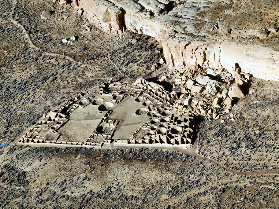
1. Chetro Ketl

Chetro Ketl is an Ancestral Puebloan great house and archeological site located in Chaco Culture National Historical Park, New Mexico, United States. Construction on Chetro Ketl began c. 990 and was largely complete by 1075, with significant remodeling occurring in the early and mid-1110s. Following the onset of a severe drought, most Chacoans emigrated from the canyon by 1140; by 1250 Chetro Ketl's last inhabitants had vacated the structure.
2. Sentinel Mesa

Monument Valley is a region of the Colorado Plateau characterized by a cluster of sandstone buttes, with the largest reaching 1,000 ft (300 m) above the valley floor. The most famous butte formations are located in northeastern Arizona along the Utah–Arizona state line. The valley is considered sacred by the Navajo Nation, the Native American people within whose reservation it lies.
3. Four Corners Monument

The Four Corners Monument marks the quadripoint in the Southwestern United States where the states of Arizona, Colorado, New Mexico, and Utah meet. It is the only point in the United States shared by four states, leading to the area being named the Four Corners region. The monument also marks the boundary between two semi-autonomous Native American governments, the Navajo Nation, which maintains the monument as a tourist attraction, and the Ute Mountain Ute Tribe Reservation.
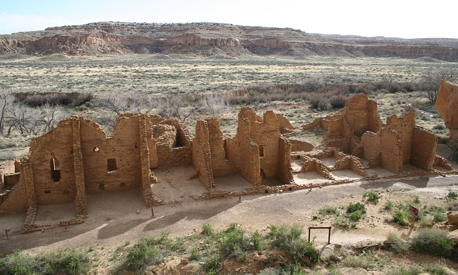
4. Pueblo Bonito Great House
Pueblo Bonito is the largest and best-known great house in Chaco Culture National Historical Park, northern New Mexico. It was built by the Ancestral Puebloans who occupied the structure between AD 828 and 1126.
5. Upheaval Dome

Upheaval Dome is an enigmatic geological structure in San Juan County, Utah, United States, that has been variously interpreted as a meteorite impact structure or a salt dome. The structure lies 22 miles (35 km) southwest of the city of Moab, Utah, in the Island in the Sky section of Canyonlands National Park.
6. Animas Forks

Animas Forks is an extinct mining town located 12 miles (19 km) northeast of Silverton in San Juan County, Colorado, United States. The area is managed by the Bureau of Land Management. At an elevation of 11,185 feet (3,409 m), Animas Forks is one of the highest mining camps in North America.
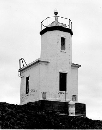
7. Patos Island Light

Patos Island Lighthouse is an active aid to navigation overlooking the Strait of Georgia at Alden Point on the western tip of Patos Island in the San Juan Islands, San Juan County, Washington, in the United States. The station is the northernmost in the San Juan Islands and marks the division point between the eastern and western passages into the Strait of Juan de Fuca.
8. Moki Dugway

State Route 261 is a state highway located entirely within south-central San Juan County, Utah. It runs 34 miles (55 km) north, from the junction of U.S. Route 163, to the junction with State Route 95, just east of Natural Bridges National Monument.
9. Mount Constitution

Mount Constitution is a mountain on Orcas Island, the highest point in the San Juan Islands and the second highest mountain on an ocean island in the contiguous 48 states. Only Devils Peak in the Channel Islands of California is higher.
10. Alkali Ridge

Alkali Ridge, also known as Alkali Point, is a set of widely scattered archaeological remains of the earliest forms of Puebloan architecture, representing a period of transition from scattered, pit-style dwellings to a settled agricultural lifestyle.
11. Lime Kiln Point Lighthouse

The Lime Kiln Light is a functioning navigational aid located on Lime Kiln Point overlooking Dead Man's Bay on the western side of San Juan Island, San Juan County, Washington, in the United States. It guides ships through the Haro Straits and is part of Lime Kiln Point State Park, which offers tours during summer months.
12. Cattle Point Lighthouse
Cattle Point Lighthouse is a lighthouse on the southeastern tip of San Juan Island overlooking the Strait of Juan de Fuca where the Haro Straits meet the San Juan Channel, in San Juan County, Washington. The light lies adjacent to the state's Cattle Point Natural Resources Conservation Area and, since 2013, is part of the San Juan Islands National Monument.
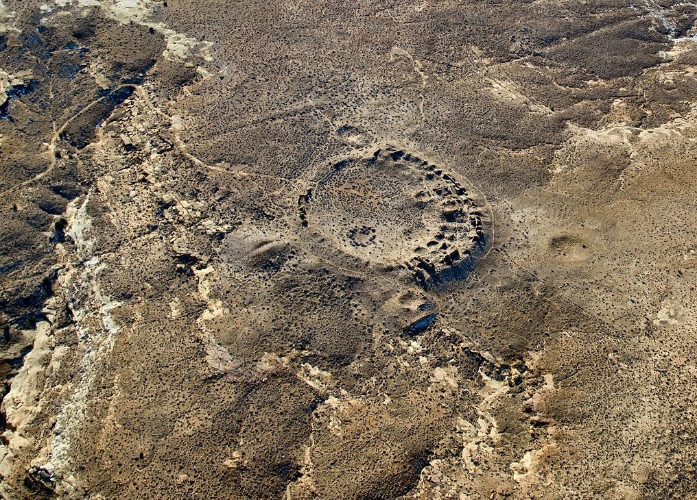
13. Casa Rinconada

Casa Rinconada is an Ancestral Puebloan archaeological site located atop a ridge adjacent to a small rincon across from Pueblo Bonito in Chaco Culture National Historical Park, northwestern New Mexico, United States.
14. Penasco Blanco
Peñasco Blanco is a Chacoan Ancestral Puebloan great house and notable archaeological site located in Chaco Canyon, a canyon in San Juan County, New Mexico, United States. The pueblo consists of an arc-shaped room block, part of an oval enclosing a plaza and great kiva, along with two great kivas outside the great house. The pueblo was built atop the canyon's southern rim to the northwest of the great houses in the main section of the canyon.
15. Blind Island

Blind Island Marine State Park is a public recreation area consisting of the entirety of Blind Island, a three-acre (1.2 ha) island at the entrance to Blind Bay on Shaw Island in San Juan County, Washington. It is part of the San Juan Islands National Monument. The island lies one-third of a mile west of the Shaw Island ferry terminal and has 1,280 feet (390 m) of saltwater shoreline. The park is cooperatively managed by the U.S. Bureau of Land Management and Washington State Parks.
16. Kin Kletso
Kin Kletso is a Chacoan Ancestral Pueblo great house and notable archaeological site located in Chaco Culture National Historical Park, 25 miles (40 km) southwest of Nageezi, New Mexico, United States. It was a medium-sized great house located 0.5 miles (0.8 km) west of Pueblo Bonito; it shows strong evidence of construction and occupation by Pueblo peoples who migrated to Chaco from the northern San Juan Basin in the time period of 1125 to 1200. From its masonry work, rectangular shape and design Kletso is identified as Pueblo III architecture by prominent Chaco archaeologists Stephen H. Lekson and Tom Windes. They also argue that this great house was only occupied by one or two households. Fagen writes that Kletso contained around 55 rooms, four ground-floor kivas, and a two-story cylindrical tower that may have functioned as a kiva or religious center. Evidence of an obsidian production industry were discovered here. The house was erected between 1125 and 1130.
17. Hungo Pavi Great House

Hungo Pavi is an Ancestral Puebloan great house and archaeological site located in Chaco Canyon, northwestern New Mexico, United States. A set of ruins located just 1 mile (2 km) from the ruins of Una Vida, Hungo Pavi measured 872 feet (266 m) in circumference. Initial explorations revealed 72 ground-level rooms, with structures reaching four stories in height. One large circular kiva has been identified. Its ruins now lie within Chaco Culture National Historical Park.
18. Pueblo Alto

Pueblo Alto is an Ancestral Puebloan great house and archaeological site located in Chaco Culture National Historical Park, northwestern New Mexico, United States. The complex, comprising 89 rooms in a single-story layout, is located on a mesa top near the middle of Chaco Canyon; 0.6 miles (1 km) from Pueblo Bonito, it was begun between AD 1020 and 1050. Its location made the community visible to most of the inhabitants of the San Juan Basin; indeed, it was only 2.3 miles (3.7 km) north of Tsin Kletsin, on the opposite side of the canyon. The community was the center of a bead- and turquoise-processing industry that influenced the development of all villages in the canyon; chert tool production was also common. It shares its mesa with another great house, Nuevo Alto, both of which are now protected within the borders of Chaco Culture National Historical Park. Storerooms at Pueblo Alto opened to the outside rather than into the interior rooms and there was a huge midden of pottery. This and chert found in the midden came mostly from the Chuska area 70 km (43 mi) to the west.
19. Mesa Arch

Mesa Arch is a pothole arch on the eastern edge of the Island in the Sky mesa in Canyonlands National Park in northern San Juan County, Utah, United States. Mesa Arch is a spectacular natural stone arch perched at the edge of a cliff with vast views of canyons, Monster Tower, Washer Woman Arch, Airport Tower, and the La Sal Mountains in the distance. Access is via a relatively easy hiking trail, just a half-mile long from the park road.
20. Candlestick Tower

Candlestick Tower is a 450-foot-tall (140 m) sandstone butte located in the Island in the Sky District of Canyonlands National Park, in San Juan County, Utah. Its descriptive name comes from its resemblance to a candlestick. Candlestick Tower is composed of Wingate Sandstone, which is the remains of wind-borne sand dunes deposited approximately 200 million years ago in the Late Triassic.
21. John S. McMillan Memorial Mausoleum
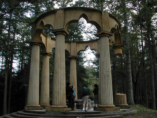
Afterglow Vista is a mausoleum located in San Juan County, Washington, United States, near Friday Harbor and Roche Harbor. It is the final resting place of businessman John S. McMillin, his wife and children, and one of the family's employees. The design of the mausoleum incorporates numerous instances of symbolism, some of it Masonic in nature.
22. Mount Tukuhnikivatz

Mount Tukuhnikivatz is a 12,482-foot elevation summit located in San Juan County of Utah, United States. Mount Tukuhnikivatz is the third-highest peak of the La Sal Mountains, and is the premier ski mountaineering destination in the La Sals. It is situated in a dry, rugged, sparsely settled region, and set on land administered by Manti-La Sal National Forest. Precipitation runoff from this mountain drains into tributaries of the Colorado River. The nearest town is Moab, 19 mi (31 km) to the northwest, and the nearest higher neighbor is Mount Peale, 1.7 mi (2.7 km) to the east. The mountain's name is a Native American word that translates as "Where the sun sets last." Locals call it Mount Tuk for short. This mountain has a subsidiary peak unofficially called Little Tuk, approximately one-half mile to the north-northwest.
23. Washer Woman

Washer Woman is a 500-foot (150-meter) tall sandstone arch and tower located in the Island in the Sky District of Canyonlands National Park, in San Juan County, Utah. It is situated 300 feet northwest of the slightly higher Monster Tower. Washer Woman is so named because the feature gives the appearance of a washerwoman bent over a washtub. This geographical feature's name was officially adopted in 1986 by the U.S. Board on Geographic Names after previously having similar names such as Washer-Woman Arch and The Washer Woman. Washer Woman and Monster Tower are an eroded fin composed of Wingate Sandstone, which is the remains of wind-borne sand dunes deposited approximately 200 million years ago in the Late Triassic. Airport Tower is set 1.6 mi (2.6 km) to the east, and Mesa Arch is situated 1.5 mi (2.4 km) to the west. A short hike to Mesa Arch provides the easiest view of Washer Woman. Access to this formation is via the four-wheel drive White Rim Road, which is the other option to see it. The top of this geological formation rises 1,300 feet above the road in approximately one mile. Precipitation runoff from Washer Woman drains southeast into the nearby Colorado River via Buck Canyon.
24. Engineer Mountain

Engineer Mountain is a 12,968-foot-elevation (3,953-meter) mountain summit located in San Juan County, Colorado, United States. It is part of the San Juan Mountains range which is a subset of the Rocky Mountains, and is west of the Continental Divide. Engineer Mountain is a prominent landmark set 1.5 mile immediately west of Coal Bank Pass, and is visible from multiple viewpoints along Highway 550, making it one of the most photographed mountains in the San Juans. It is situated 11 miles southwest of the community of Silverton, on land managed by San Juan National Forest. Topographic relief is significant as the southwest aspect rises 3,800 feet above Cascade Creek in approximately two miles. Neighbors include Snowdon Peak seven miles to the east, and Twilight Peak, five miles to the southeast.
25. Mount Mellenthin

Mount Mellenthin is a 12,645-foot elevation summit located in San Juan County of Utah, United States. Mount Mellenthin is the second-highest peak of the La Sal Mountains, and second-highest in the county. It is situated in a dry, rugged, sparsely settled region, and set on land administered by Manti-La Sal National Forest. Precipitation runoff from this mountain drains into tributaries of the Colorado River. The nearest town is Moab, 20 mi (32 km) to the northwest, and the nearest higher neighbor is Mount Peale, 1.7 mi (2.7 km) to the south. The mountain's name honors Rudolf E. Mellenthin (1884–1918), forest ranger of La Sal National Forest, who was shot to death near this peak on August 23, 1918, while attempting to apprehend two draft evaders. This geographical feature's toponym was officially adopted in 1932 by the U.S. Board on Geographic Names.
Share
How likely are you to recommend us?
Disclaimer Please be aware of your surroundings and do not enter private property. We are not liable for any damages that occur during the tours.