Self-guided Sightseeing Tour #2 in Görlitz, Germany
Legend
Tour Facts
4.2 km
60 m
Experience Görlitz in Germany in a whole new way with our free self-guided sightseeing tour. This site not only offers you practical information and insider tips, but also a rich variety of activities and sights you shouldn't miss. Whether you love art and culture, want to explore historical sites or simply want to experience the vibrant atmosphere of a lively city - you'll find everything you need for your personal adventure here.
Individual Sights in GörlitzSight 1: Wilhelmsplatz

The rectangular Wilhelmsplatz in the southern city centre is the largest Görlitz town square with an east-west extension of over 200 m and a north-south extension of around 100 m. The centre of the square is a large lawn surrounded by flower beds as planting ribbons. A row of hedges and trees separates the green square from the busy Jakobstraße in the west. Wilhelmsplatz is located between the city center and Görlitz train station.
Sight 2: Joliot-Curie-Gymnasium

The Joliot-Curie-Gymnasium is a general education school in the secondary education sector that leads to the university entrance qualification. The school, which emerged from the Luisenschule, is located on the north side of Wilhelmsplatz in the East Saxon city of Görlitz. It is one of two grammar schools in the city and is under their sponsorship. The Gymnasium offers the natural and social science profiles.
Sight 3: Straßburg-Passage

The Straßburg-Passage is a shopping arcade built in 1908 in Görlitz. It is an architectural monument in Art Nouveau style and connects Berliner Straße with Wilhelmsplatz.
Sight 4: Dr. Fritz Warschawski
The list of stumbling stones in Görlitz contains all 81 stumbling stones that were laid at 29 locations in the city of Görlitz as part of the project of the same name by Gunter Demnig. Three of them, for the Goldberg family, commemorate Jewish families in the former Görlitz Oststadt Zgorzelec. They are intended to commemorate victims of National Socialism who lived and worked in Görlitz.
Sight 5: Girl with the Shell

The Muschelminna, also called Toberentzbrunnen after its architect Robert Toberentz, is a fountain built in 1887 on the Postplatz in the city of Görlitz. The name originated from the vernacular that referred to the bronze statue standing on the marble pedestal. The statue was melted down during World War II. Since 1994, a faithful replica has been on display on the fountain.
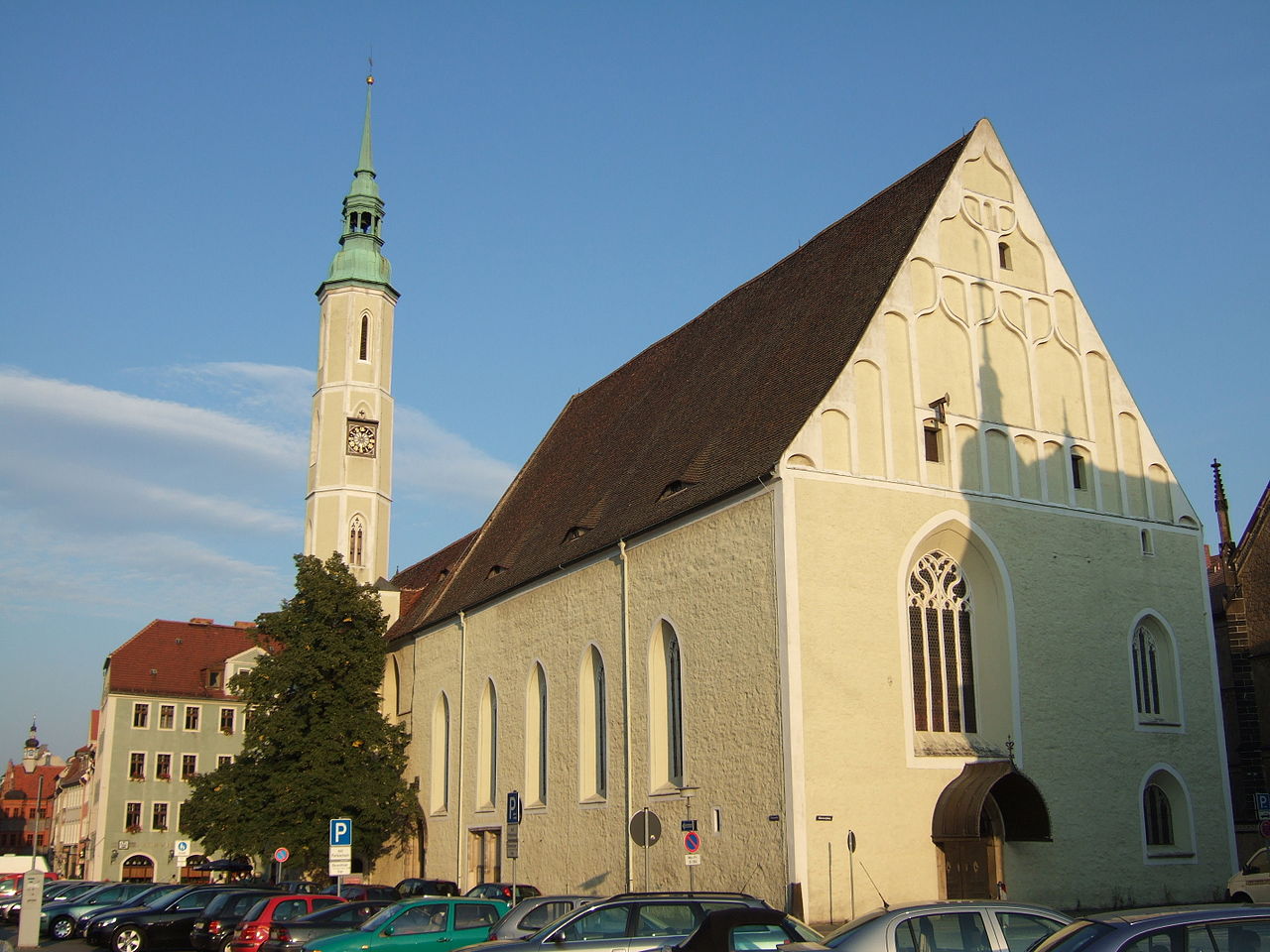
Sight 6: Church of Our Lady

The Frauenkirche is a three-aisled hall church in the late Gothic style. The church was once located at the gates of the city of Görlitz. In the meantime, however, it is located in the middle of the center and shapes the image of the city center. In the autumn of 1989, it was the starting point for the prayers for peace in the city.
Sight 7: Kaufhaus Görlitz

The Görlitz department store, also known as Zum Strauss and Warenhaus Görlitz, is a listed building in Görlitz, built in the style of historicism and decorated with elements of Art Nouveau.
Sight 8: Gerhart Hauptmann-Theater

The Görlitz Theatre is a theatre building for opera and drama in the East Saxon town of Görlitz. The building is popularly known as the Little Semper Opera House due to its opulent interior.
Sight 9: The Imperial Stronghold

The Kaisertrutz is one of the once 32 bastions, four of which are still preserved today, which the city of Görlitz possessed for defense.
Sight 10: Senckenberg Museum für Naturkunde Görlitz

The Senckenberg Museum for Natural History Görlitz or Senckenberg Museum für Naturkunde Görlitz in Görlitz, Germany is a natural history museum with focus on zoology, botany and geology. Since 2009, the museum has been part of the Senckenberg Gesellschaft für Naturforschung with headquarters in Frankfurt/Main. The main field of research is soil biology. In the years 2006 to 2017 the number of visitors was between 25,000 and 34,000, in the year of the 3rd Saxon State Exhibition 2011 it was even 47,000.
Wikipedia: Senckenberg Museum for Natural History Görlitz (EN), Website
Sight 11: Frauenturm (Dicker Turm)

The Thick Tower erected in 1250 is part of the historic fortification of Görlitz. The 46-metre (151 ft) tall tower is the most massive tower in the city. Its walls in the lower part reach a thickness of 5.34 metres (17.5 ft), thus the name of a thick tower. Apart from it, the Nikolai Tower and the Reichenbach Tower are still preserved. In total, Görlitz had four large watchtowers and defense towers.
Sight 12: Annenkapelle

The Anne Chapel on Görlitz's Marienplatz was built between 1508 and 1511 by the council architect Albrecht Stieglitzer as a memorial chapel for the Görlitz merchant Hans Frenzel the Rich (1463–1526). It was dedicated to St. Anne – Frenceslas' patron saint. Later it was used as an orphanage and prison church. Today, the former chapel is used as a gymnasium and auditorium of the adjacent Annenschule.
Sight 13: Reichenbach Tower

The Reichenbach Tower probably built in the 13th century and first mentioned in 1376 is the western part of the historic fortification of Görlitz. With a height of 51m it is the tallest of the three fortified towers in Görlitz..
Sight 14: Obermarkt

The Upper Market Square in Görlitz is the largest square in the historic part of the town. It was laid out in 1250 together with the Lower Market Square. Both are connected via the Bretheren Street (Brüderstraße). While the Lower Market is mostly bordered by Renaissance buildings, the Upper Market has many buildings from the Baroque and Wilhelminian periods. It is therefore the gateway to the historic part of the town. Important buildings on the market include Reichenbach Tower, Kaisertrutz and Holy Trinity Church (Dreifaltigkeitskirche).
Sight 15: Dreifaltigkeitskirche
The Holy Trinity Church is a Protestant church in Görlitz, Germany. It was built between 1234 and 1245 as the monastery church of the Franciscan monastery on today's Obermarkt. In 1564 the monastery was converted into a grammar school, the church served as a school church and since 1712 as a parochial church.
Wikipedia: Dreifaltigkeitskirche (Görlitz) (DE), Website, Heritage Website
Sight 16: Brüderstraße

The Brüderstraße in Görlitz is part of the historic city centre and has numerous buildings from the Renaissance. It connects the Görlitz Obermarkt with the Untermarkt and is part of the Via regia. It is named after the Franciscan brothers, to whose former monastery on the Obermarkt the Brüdergasse led.
Sight 17: Schlesisches Museum

The Silesian Museum in Görlitz was opened on 13 May 2006 in an architecturally newly composed complex that combines four historic buildings: the Schönhof, the Mittelhaus, the building at the Fischmarkt, both of which date from 1832, and the Hallenhaus at Untermarkt 4.
Sight 18: Schönhof

The Schönhof is the oldest Renaissance-building in Görlitz, Germany. The building on Bretheren Street 8 (Brüderstraße) was constructed by Wendel Roskopf in 1526 over the surviving stone foundations after the town fire in 1525.
Sight 19: Frenzelhof

The Hallenhaus Untermarkt 5 is a protected cultural monument located opposite the town hall on the Untermarkt in Görlitz. Built in the 15th century, the Frenzelhof is one of the oldest hall houses in Görlitz. For the construction phase around 1500, there are a number of historical references that are associated with the name Hans Frenzel.
Sight 20: Fischmarkt

The fish market is a square on the southern edge of the historic old town of Görlitz. Compared to the two other large town squares in the old town, the Untermarkt and Obermarkt, it is one of the younger street layouts in the historic city centre.
Sight 21: Ochsenbastei

The Ochsenbastei in Görlitz is part of the former city fortifications near St. Peter's Church. While the actual "Tor an der Kahle" was demolished in 1834, the rotunda of the bastion and the ox kennel were preserved and are now protected as cultural monuments.
Sight 22: Heilig-Kreuz-Kirche

The Holy Cross Church was the first post-Reformation Catholic church building in the city of Görlitz and is located in the immediate vicinity of the synagogue and the city park.
Sight 23: Cultural Centre Synagogue of Goerlitz

.jpg)
The Görlitz Synagogue is a Jewish congregation and synagogue, located on Otto-Müller-Straße, in Görlitz, Germany. Built between 1909 and 1911 in the Art Nouveau style, the synagogue was the main place of worship for the city's Ashkenazi Jewish community. Despite an arson attack, the synagogue was one of the few synagogues in the area to survive Kristallnacht, sustaining only minor damage. The damage was lessened as firefighters ignored the Nazi German orders to let the synagogue burn. With the city's Jewish population depleted, the unused synagogue became a ruin in the following decades.
Wikipedia: Görlitz Synagogue (EN), Website, Heritage Website
Sight 24: Municipal Park

The Stadtpark is an inner-city green space in the East Saxon city of Görlitz.
Share
How likely are you to recommend us?
Disclaimer Please be aware of your surroundings and do not enter private property. We are not liable for any damages that occur during the tours.
GPX-Download For navigation apps and GPS devices you can download the tour as a GPX file.