Self-guided Sightseeing Tour #3 in Witten, Germany
Legend
Tour Facts
2.8 km
169 m
Experience Witten in Germany in a whole new way with our self-guided sightseeing tour. This site not only offers you practical information and insider tips, but also a rich variety of activities and sights you shouldn't miss. Whether you love art and culture, want to explore historical sites or simply want to experience the vibrant atmosphere of a lively city - you'll find everything you need for your personal adventure here.
Individual Sights in WittenSight 1: Westlicher Tagetrieb Frielinghaus

The Frielinghaus colliery in the Vormholz-Hardenstein district of Witten is a former coal mine. The colliery was also known as the Frielinghaus Gerichts Herbede colliery. From 1832, the colliery was also known as the Frielinghaus Tiefbau colliery, Frielinghausen colliery or Frilinghausen colliery. Parts of the mine are now part of the Muttental mining trail.
Sight 2: Hardenstein Castle
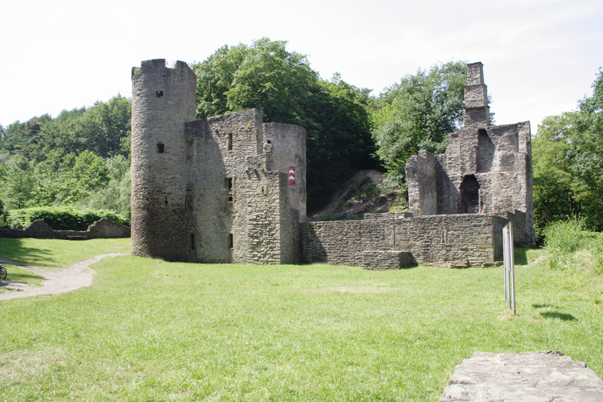
Hardenstein Castle is a ruined castle in North Rhine-Westphalia, Germany. The remains lie east of Herbede on the Ruhr River, surrounded by mountains, and are not easily accessible. Nearby ruins show that the castle was once part of an important mining centre, probably dating to the Middle Ages; the earliest records, from the 16th century, support this. The castle features in the legend of the Nibelungs.
Sight 3: St. Johannes Erbstollen

The St.-Johannes-Erbstollen is a former Erbstollen in Witten in the districts of Hardenstein and Vormholz. The tunnel is located west of the Muttental. The tunnel was also known under the names Tiefer Johannis Stollen, St. Johannes Erbstolln, St. Johannis-Erbstollen, Johannis Erbstollen and Johannes Erbstollen. Its lower part runs in the valley of an unnamed stream, which is locally called Deipenbecke or simply Hardensteiner Bach. The St.-Johannes-Erbstollen was the most important tunnel in the region and was used to drain water and ventilate the surrounding mines, which were mining hard coal. The Erbstollen belonged to the Märkischer Bergamtsbezirk.
Sight 4: Schleusenwärterhaus

The Königliche Schleusenwärterhaus is a lock keeper's house on the Ruhr in Heven, Witten, near the Herbeder Schleuse. It is a listed building.
Sight 5: Vereinigungsstollen

The Vereinigungsstollen is a former tunnel in Witten-Hardenstein. The tunnel was also known as the Compagniestollen or Vereinigungs Förderstollen (Association Conveyor Tunnel). After completion, the tunnel had a total length of around 375 metres transversely and a maximum height of 1.8 metres. The tunnel is still used today to drain the old mine field.
Sight 6: Stollen Turteltaube

The Turteltaube colliery was a mine in Bommern in the Muttental. The mine belonged to the court of Herbede. The mine was built on two wings, each with a separate tunnel in the nightingale hollow, and was in operation until the middle of the 19th century.
Share
Disclaimer Please be aware of your surroundings and do not enter private property. We are not liable for any damages that occur during the tours.
GPX-Download For navigation apps and GPS devices you can download the tour as a GPX file.