Self-guided Sightseeing Tour #2 in Coimbra, Portugal
Legend
Guided Free Walking Tours
Book free guided walking tours in Coimbra.
Guided Sightseeing Tours
Book guided sightseeing tours and activities in Coimbra.
Tour Facts
1.2 km
39 m
Experience Coimbra in Portugal in a whole new way with our self-guided sightseeing tour. This site not only offers you practical information and insider tips, but also a rich variety of activities and sights you shouldn't miss. Whether you love art and culture, want to explore historical sites or simply want to experience the vibrant atmosphere of a lively city - you'll find everything you need for your personal adventure here.
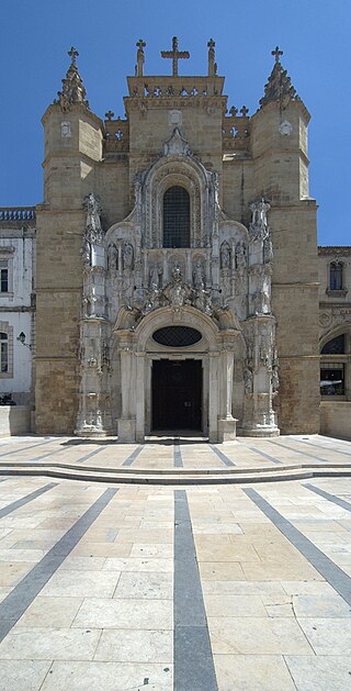
Activities in CoimbraIndividual Sights in CoimbraSight 1: Igreja de Santa Cruz
The Monastery of the Holy Cross, also known as the Church of the Holy Cross, is a National Monument in Coimbra, Portugal. Because the first two kings of Portugal are buried in the church it was granted the status of National Pantheon. Founded in 1131 outside the protecting walls of Coimbra, the Monastery of the Holy Cross was the most important monastic house during the early days of the Portuguese monarchy. Saint Theotonius founded this community of Canons Regular of the Holy Cross of Coimbra and served as their first prior. The monastery and church were erected between 1132 and 1223. The monastery was granted numerous papal privileges and royal grants, which allowed the accumulation of considerable wealth, at the same time as it consolidated its position on the politico-institutional and cultural scene. Its school, with its vast library, was highly respected in medieval times and was a meeting point for the intellectual and power elites. Its scriptorium was used for the consolidation of royal power by King Afonso Henriques, thus it was not considered strange that he decided to be buried there.
Wikipedia: Monastery of the Holy Cross (Coimbra) (EN), Heritage Website Sipa, Heritage Website
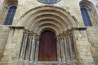
Sight 2: Igreja de São Tiago
Igreja de Santiago is a church located at Praça do Comércio in São Bartolomeu parish, Coimbra, Portugal. Built between the late 12th and early 13th centuries, it is one of the great Romanesque monuments of the city, and is classified as a National Monument.
Wikipedia: Igreja de Santiago (Coimbra) (EN), Heritage Website Sipa, Heritage Website
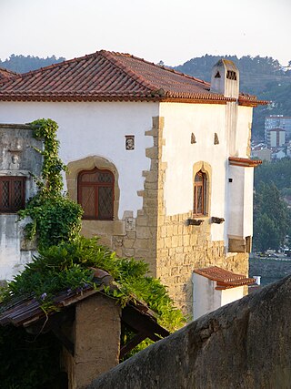
Sight 3: Palácio Sub-Ripas
The Palace of Sobre-Ribas, also referred to as Paço de Sub-Ripas and Casa de Sub-Ripas, is located in the parish of Coimbra, municipality of Coimbra, district of Coimbra, in Portugal.
Wikipedia: Paço de Sobre-Ribas (PT), Heritage Website Sipa, Heritage Website
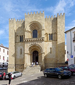
Sight 4: Sé Velha de Coimbra
The Old Cathedral of Coimbra is a Romanesque Roman Catholic building in Portugal. Construction of the Sé Velha began some time after the Battle of Ourique (1139), when Prince Afonso Henriques declared himself King of Portugal and chose Coimbra as capital. The first Count of Coimbra, the Mozarab Sisnando Davides, is buried in the cathedral.
Sight 5: Porta Férrea, Paço das Escolas (Alta)
It is called the University of Coimbra - Alta and Sofia, the historical-cultural complex classified as a UNESCO World Heritage Site in 2013, housing 4 parishes of the Historic Center of Coimbra located in the city of Coimbra, Portugal. The University of Coimbra is one of the oldest universities still in operation in the world and the oldest in Portugal and the Portuguese-speaking countries and regions.
Share
Disclaimer Please be aware of your surroundings and do not enter private property. We are not liable for any damages that occur during the tours.
GPX-Download For navigation apps and GPS devices you can download the tour as a GPX file.


.jpg)