Self-guided Sightseeing Tour #2 in Badalona, Spain
Legend
Tour Facts
4.6 km
121 m
Experience Badalona in Spain in a whole new way with our self-guided sightseeing tour. This site not only offers you practical information and insider tips, but also a rich variety of activities and sights you shouldn't miss. Whether you love art and culture, want to explore historical sites or simply want to experience the vibrant atmosphere of a lively city - you'll find everything you need for your personal adventure here.
Individual Sights in BadalonaSight 1: Parc del Turó d'en Caritg
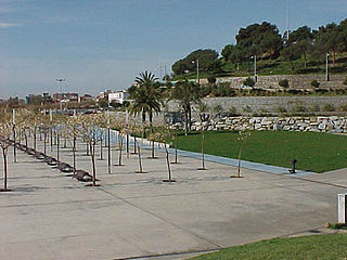
The Turó d'en Caritg, the official name given by the Badalona City Council, although it has also been standardised by the ICGC as Turó d'en Carig, and formerly known as Turó d'en Claris, is a small elevation in the city of Badalona that has now been converted into an urban park. It is located in the neighborhood of Sistrells and stands out for being the second highest point of the Sierra de en Mena, at an altitude of 71m.
Sight 2: Escorxador Municipal de Badalona

The old municipal slaughterhouse of Badalona is a noucentista work protected as a cultural asset of local interest in the municipality of Badalona (Barcelonès).
Sight 3: Mare de Déu de la Salut
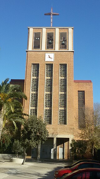
The Church of Our Lady of Health is a Catholic parish church in the La Salut district of Badalona, on Paseo de La Salut, no. 38. It belongs to the archpriesthood of Badalona sud, in the archbishopric of Barcelona.
Wikipedia: Església de la Mare de Déu de la Salut (Badalona) (CA)
Sight 4: parc del Gran Sol

El Parc del Gran Sol és un parc situat al barri de Sant Joan de Llefià de Badalona. Té 1,80 ha i està delimitat per l'avinguda Doctor Bassols, el carrer Àsia, Juan Valera i l'avinguda Àfrica, amb accessos en tots els carrers perimetrals. Fou inaugurat el 1985 i es tracta d'un parc urbà d'ús veïnal ubicat dintre d'un sector d'habitatges d'alta densitat.
Sight 5: Blas Infante
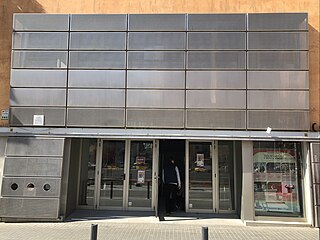
The Blas Infante Theater is a cultural center and theater in Badalona (Barcelona). It is located on Andrés Segovia street, in the Sant Mori neighborhood of Llefià, being the only one of the public theaters in Badalona that is not located in the Center neighborhood.
Sight 6: Centre Cívic Torre Mena
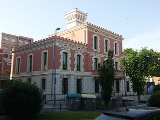
The Mena Tower is a building protected as a cultural asset of local interest in Badalona (Barcelona).
Sight 7: Can Rigalt

Can Rigalt, also called Can Barnola, is an old farmhouse located on the corner of Avinguda de Pi i Margall and Carrer Major de Sant Adrià de Besòs, listed as a cultural asset of local interest. It is currently owned by the municipality.
Wikipedia: Can Rigalt (Sant Adrià de Besòs) (CA), Ref Bcil Website, Heritage Website
Sight 8: Ateneu Adrianenc
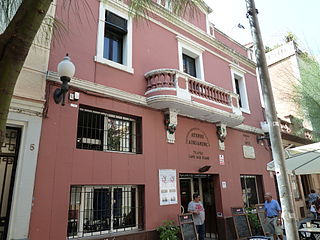
The Ateneu Adrianenc is an athenaeum and multipurpose hall in Sant Adrià de Besòs, located at 7 Andreu Vidal Street. Private, it was founded in 1925 with the aim of promoting culture among the people of Adrian. It is currently the place where many of the city's associations have their headquarters and numerous cultural activities are carried out there. The building, in the Noucentista style and built around the middle of the twentieth century, is listed as an architectural heritage.
Wikipedia: Ateneu Adrianenc (CA), Ref Bcil Website, Website, Heritage Website
Sight 9: Casal de la Dona
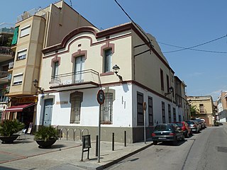
The Casal de la Dona is a mid-nineteenth-century building in Sant Adrià de Besòs (Barcelona). Throughout its history it has had various uses: housing, school, court, among others. Currently, since 1984, it has been used today as a women's centre of the Sant Adrià women's association.
Wikipedia: Casal de la Dona (Sant Adrià de Besòs) (CA), Ref Bcil Website, Heritage Website
Sight 10: Església de Sant Adrià
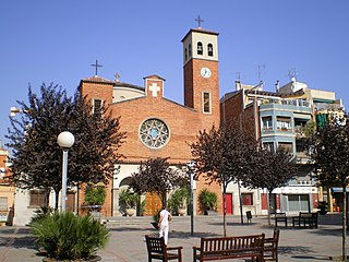
The church of Sant Adrià is a Catholic parish church in the municipality of Sant Adrià de Besòs (Barcelona). Its existence is documented in the eleventh century. The current temple was built in 1940, after the destruction of the old one in 1936 during the civil war.
Wikipedia: Església parroquial de Sant Adrià de Besòs (CA), Ref Bcil Website, Heritage Website
Share
Disclaimer Please be aware of your surroundings and do not enter private property. We are not liable for any damages that occur during the tours.
GPX-Download For navigation apps and GPS devices you can download the tour as a GPX file.