Self-guided Sightseeing Tour #1 in New Haven, United States
Legend
Tour Facts
2.3 km
42 m
Experience New Haven in United States in a whole new way with our free self-guided sightseeing tour. This site not only offers you practical information and insider tips, but also a rich variety of activities and sights you shouldn't miss. Whether you love art and culture, want to explore historical sites or simply want to experience the vibrant atmosphere of a lively city - you'll find everything you need for your personal adventure here.
Individual Sights in New HavenSight 1: Wooster Square Historic District

The Wooster Square Historic District encompasses much of the Wooster Square neighborhood of New Haven, Connecticut. Centered on a rectangular park named in honor of General David Wooster, the area was developed as a residential neighborhood beginning in the 1820s, and was by the 1840s a desirable area to live, with many high-quality Greek Revival homes. In the 1950s the area was the subject of a major community-led preservation effort that drew national attention. The district was listed on the National Register of Historic Places in 1971.
Wikipedia: Wooster Square Historic District (EN), Heritage Website
Sight 2: Wooster Square

Wooster Square is a neighborhood in the city of New Haven, Connecticut, to the east of downtown. The name refers to a park square located between Greene Street, Wooster Place, Chapel Street and Academy Street in the center of the neighborhood. Wooster Square is also known as Little Italy: a bastion of Italian American culture and cuisine, and is home to some of New Haven's, best-known pizza eateries, including Frank Pepe Pizzeria Napoletana and Sally's Apizza. The square and much of the neighborhood are included in the Wooster Square Historic District, which was listed on the National Register of Historic Places in 1971.
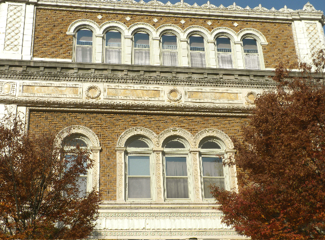
Sight 3: Imperial Granum-Joseph Parker Buildings

The Imperial Granum-Joseph Parker Buildings, also known historically as the Del Monico Building, are a pair of conjoined historic commercial buildings at Elm and Orange Streets in downtown New Haven, Connecticut. Built in 1875 and 1877, the two buildings are among the finest examples of the architecture of that period in the city, with one sporting one of the city's only surviving cast iron facades. The buildings were listed on the National Register of Historic Places in 1986.
Sight 4: Ninth Square Historic District

The Ninth Square Historic District encompasses a historically diverse and well-preserved part of the commercial area of Downtown New Haven, Connecticut. The district is bounded by Church, Court, State, and Crown Streets, and is centered on the intersection of Chapel and Orange Streets. The buildings in the district are mostly late-19th and early 20th commercial buildings, and includes a number of commercial buildings from the first half of the 19th century, a rarity in most of Connecticut's urban downtown areas. The district was listed on the National Register of Historic Places in 1984.
Wikipedia: Ninth Square Historic District (EN), Heritage Website
Sight 5: Chapel Street Historic District
The Chapel Street Historic District is a 23-acre (9.3 ha) historic district in the Downtown New Haven area of the city of New Haven, Connecticut. It was listed on the National Register of Historic Places in 1984. The district covers the southwestern corner of Downtown New Haven, including properties from Park Street to Temple Street between Chapel and Crown streets, and properties from High Street to Temple Street between George and Crown streets. It is bordered on the north by the New Haven Green and the Yale University campus. The western edge borders the Dwight Street Historic District. The eastern and southern edges of the district abut areas of more modern development.
Wikipedia: Chapel Street Historic District (EN), Heritage Website
Sight 6: Yale Center for British Art

The Yale Center for British Art at Yale University in central New Haven, Connecticut, houses the largest and most comprehensive collection of British art outside the United Kingdom. The collection of paintings, sculpture, drawings, prints, rare books, and manuscripts reflects the development of British art and culture from the Elizabethan period onward.
Sight 7: Elisha Blackman Building

The Elisha Blackman Building, also known as the York-Chapel Building, is a historic mixed commercial-residential building at 176 York Street in the Downtown New Haven neighborhood of New Haven, Connecticut. Built in 1883, it is a finely crafted example of 19th-century commercial architecture, and is one of the few such buildings to survive in the city. It was listed on the National Register of Historic Places in 1978.
Share
How likely are you to recommend us?
Disclaimer Please be aware of your surroundings and do not enter private property. We are not liable for any damages that occur during the tours.
GPX-Download For navigation apps and GPS devices you can download the tour as a GPX file.