Self-guided Sightseeing Tour #5 in San Francisco, United States
Legend
Guided Free Walking Tours
Book free guided walking tours in San Francisco.
Guided Sightseeing Tours
Book guided sightseeing tours and activities in San Francisco.
Tour Facts
6.4 km
272 m
Experience San Francisco in United States in a whole new way with our free self-guided sightseeing tour. This site not only offers you practical information and insider tips, but also a rich variety of activities and sights you shouldn't miss. Whether you love art and culture, want to explore historical sites or simply want to experience the vibrant atmosphere of a lively city - you'll find everything you need for your personal adventure here.
Activities in San FranciscoIndividual Sights in San FranciscoSight 1: Mohandas K. Gandhi

Mohandas K. Gandhi is a 1988 bronze sculpture of Mahatma Gandhi sculpted by Zlatko Paunov and Steven Lowe. It is located in the plaza to the southeast of the San Francisco Ferry Building along the Embarcadero in San Francisco, California, United States. The 8-foot (2.4 m) tall sculpture is mounted on a block which bears a plaque, raised on two steps. It was a gift from the Gandhi Memorial International Foundation.
Sight 2: Santa Rosa

Santa Rosa was a Steel Electric-class ferry built in Alameda, California, for Northwestern Pacific Railroad. She started out serving Southern Pacific Railways on their Golden Gate Ferries line on San Francisco Bay.
Sight 3: Transamerica Pyramid
Join Free Tour*
The Transamerica Pyramid is a pyramid-shaped 48-story modernist skyscraper in San Francisco, California, United States, and the second tallest building in the San Francisco skyline. Located at 600 Montgomery Street between Clay and Washington Streets in the city's Financial District, it was the tallest building in San Francisco from its completion in 1972 until 2018 when the newly-constructed Salesforce Tower surpassed its height. The building no longer houses the headquarters of the Transamerica Corporation, which moved its U.S. headquarters to Baltimore, Maryland. The building is still associated with the company by being depicted on the company's logo. Designed by architect William Pereira and built by Hathaway Dinwiddie Construction Company, the building stands at 853 feet (260 m). On completion in 1972 it was the eighth-tallest building in the world. It is also a popular tourist site. In 2020, the building was sold to NYC investor Michael Shvo, who in 2022 hired Norman Foster to redesign the interiors and renovate the building.
Sight 4: Sentinel Building

Columbus Tower, also known as the Sentinel Building, is a mixed-use building in San Francisco, California, completed in 1907. The distinctive copper-green Flatiron style structure is bounded by Columbus Avenue, Kearny Street, and Jackson Street; straddling the North Beach, Chinatown, and Financial District neighborhoods of the city. Much of the building is occupied by film studio American Zoetrope, and the ground floor houses a cafe named after the company. The Sentinel Building is listed as San Francisco Designated Landmark No. 33.
Sight 5: City Lights Booksellers

City Lights is an independent bookstore-publisher combination in San Francisco, California, that specializes in world literature, the arts, and progressive politics. It also houses the nonprofit City Lights Foundation, which publishes selected titles related to San Francisco culture. It was founded in 1953 by poet Lawrence Ferlinghetti and Peter D. Martin. Both the store and the publishers became widely known following the obscenity trial of Ferlinghetti for publishing Allen Ginsberg's influential collection Howl and Other Poems. Nancy Peters started working there in 1971 and retired as executive director in 2007. In 2001, City Lights was made an official historic landmark. City Lights is located at 261 Columbus Avenue. While formally located in Chinatown, it self-identifies as part of immediately adjacent North Beach.
Wikipedia: City Lights Bookstore (EN), Website, Opening Hours, Youtube
Sight 6: Ma-Tsu Temple

The Ma-Tsu Temple is a Taoist temple in San Francisco's Chinatown. Founded in 1986, it is dedicated to Matsu and has foundational ties to the Chaotian Temple in Beigang, Yunlin, Taiwan.
Sight 7: Goddess of Democracy

Goddess of Democracy is a replica of the original Goddess of Democracy statue created during the Tiananmen Square protests of 1989, installed in San Francisco's Chinatown, in the U.S. state of California. The sculpture stands in Portsmouth Square.
Sight 8: Kong Chow Temple

Kong Chow Temple is a temple dedicated to Guan Di, located in the Chinatown neighborhood of San Francisco, California, in the United States.
Sight 9: Tin How Temple
Get Ticket*
The Tin How Temple is the oldest extant Taoist temple in San Francisco's Chinatown, and one of the oldest still-operating Chinese temples in the United States. It is dedicated to the Chinese sea goddess Mazu, who is known as Tin How in Cantonese.
Sight 10: Saint Mary's Square

Saint Mary's Square is a park and urban square across California Street from Old St. Mary's Cathedral in San Francisco's Chinatown, in the U.S. state of California.
Sight 11: Sun Yat-sen's statue

Sun Yat-sen is an outdoor sculpture depicting the Chinese physician, writer, and philosopher of the same name by Beniamino Bufano, installed in San Francisco's Saint Mary's Square, in 1937, in the U.S. state of California.
Sight 12: Comfort Women Column of Strength

The San Francisco Comfort Women memorial is a monument dedicated to comfort women before and during World War II. It is built in remembrance of the girls and women that were sexually enslaved by the Imperial Japanese Army through deceit, coercion, and brutal force. It is approximated that there were around 400,000 "comfort women" from Korea, Taiwan, China, Indonesia, the Philippines and other Asian countries. The site is located near the Saint Mary's Square, at the crossroads of San Francisco Chinatown and the Financial District. The statue "Comfort Women" Column of Strength, by sculptor Steven Whyte, is one of nine and the first sculpture placed in a major U.S. city to commemorate the comfort women.
Sight 13: Lotta's Fountain

Lotta's fountain is a fountain at the intersection of Market Street, where Geary and Kearny Streets connect in downtown San Francisco, California. It was commissioned by actress Lotta Crabtree in 1875 as a gift to the city of San Francisco, and would serve as a significant meeting point in the aftermath of the 1906 San Francisco earthquake and fire.
Sight 14: San Francisco Museum of Modern Art
Get Ticket*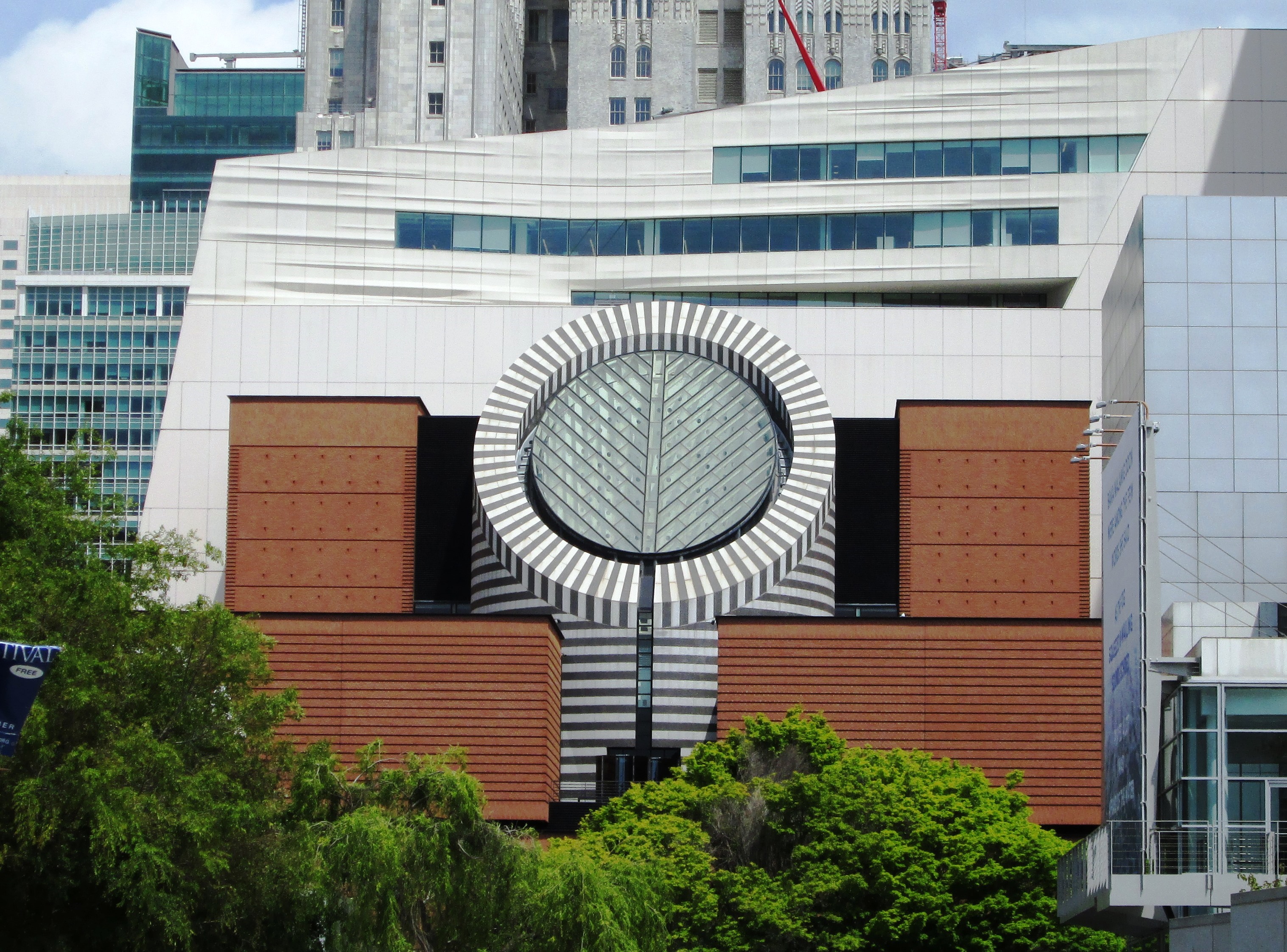
The San Francisco Museum of Modern Art (SFMOMA) is a modern and contemporary art museum and nonprofit organization located in San Francisco, California. SFMOMA was the first museum on the West Coast devoted solely to 20th-century art, and has built an internationally recognized collection with over 33,000 works of painting, sculpture, photography, architecture, design, and media arts. The collection is displayed in 170,000 square feet (16,000 m2) of exhibition space, making the museum one of the largest in the United States overall, and one of the largest in the world for modern and contemporary art.
Sight 15: Yerba Buena Gardens

Yerba Buena Gardens is the name for two blocks of public parks located between Third and Fourth, Mission and Folsom Streets in the South of Market (SoMA) neighbourhood of San Francisco, California. The first block bordered by Mission and Howard Streets was opened on October 11, 1993. The second block, between Howard and Folsom Streets, was opened in 1998, with a dedication to Martin Luther King Jr. by Mayor Willie Brown. A pedestrian bridge over Howard Street connects the two blocks, sitting on top of part of the Moscone Center convention center. The Yerba Buena Gardens were planned and built as the final centerpiece of the Yerba Buena Redevelopment Area which includes the Yerba Buena Center for the Arts. Yerba Buena Gardens Conservancy operates the property on behalf of the City and County of San Francisco.
Sight 16: Shaking Man

Shaking Man is a 1993 bronze sculpture by Terry Allen, installed at Yerba Buena Gardens, in San Francisco's South of Market neighborhood, in the U.S. state of California.
Sight 17: Old San Francisco Mint

The Old San Francisco Mint is a building that served as the location of the San Francisco branch of the United States Mint from 1874 until 1937. The building is one of the few that survived the great 1906 San Francisco earthquake and resulting fire. It was designated a National Historic Landmark in 1961, and as a California Historical Landmark in 1974.
Sight 18: Warfield Theatre

The Warfield Theatre, colloquially called The Warfield, is a 2,300-seat music venue located in the Theatre District in downtown San Francisco, California, United States. It was built as a vaudeville theater and opened as the Loews Warfield on May 13, 1922.
Share
How likely are you to recommend us?
Disclaimer Please be aware of your surroundings and do not enter private property. We are not liable for any damages that occur during the tours.
GPX-Download For navigation apps and GPS devices you can download the tour as a GPX file.